Section 19: Historical Markers
Anchor: #i1010460Introduction
Historical markers are used to interpret, promote, and protect historic and cultural resources. Requests for markers are initiated through local county historical commissions and approved through the Texas Historical Commission (THC). The Texas Department of Transportation (TxDOT) Traffic Operations Division (TRF) works with the THC to approve markers placed on TxDOT right-of-way. TxDOT provides advance and directional guide signs for all historical markers on TxDOT right-of-way outside of city limits on conventional highways.
Anchor: #i1010470Historical Marker Process Overview
All requests for historical markers made by the public should be directed to the local county historical commission. If the marker will be placed on TxDOT right-of-way, the process of approval and installation proceeds as follows:
|
Step |
Responsible Party |
Action |
|---|---|---|
| 1 |
County historical commission |
Upon concurring with the request, applies to the Texas Historical Commission (THC). The necessary forms and instructions can be downloaded on the Historical Marker Tool Box page of the THC website. |
| 2 |
THC |
Reviews the request and, upon approval, sends a memorandum detailing the proposed historical marker and its wording, along with the marker number (from the Texas Historic Sites Atlas), job number, and contact person, to TRF. |
| 3 |
TRF |
Reviews the memorandum and associated data and, upon approval, sends a form memorandum, along with the marker and job number and Atlas number and name of contact person, to the appropriate district office. |
| 4 |
THC |
Provides the historical marker to the district. |
| 5 |
District office |
Works with the chairman of the local county historical commission to determine the actual placement location for the historical marker (see following segment on “Marker Placement”). The district installs the marker (see “Design and Installation of Markers” later in this section) and also provides and installs advance and directional guide signs using the guidelines in this section and the Texas Manual on Uniform Traffic Control Devices (TMUTCD). |
Anchor: #i1010479
Marker Placement
The safety of the traveling public is a major priority in the location of the historical marker itself. The markers are not mounted on breakaway supports and have not been tested for vehicle impacts; therefore, they are to be considered non-breakaway. They should be located outside the clear zone or protected or not installed at all.
TxDOT policy specifies that markers be located in roadside parks, at existing turnouts, or at a specially prepared turnout. The primary effort in locating these markers should be to utilize existing facilities. Where such cannot be done, locations should be selected that would require a minimum amount of improvement. In these instances, the usage by the public should determine the extent of development necessary. Often soil conditions will require only minor grading or a minimum amount of stabilization. Surfacing will be justified for very few marker facilities. TxDOT strives to cooperate with the historical marker program by placing markers in locations accessible to the public. Nevertheless, the scope of the program is such that the economic aspects deserve careful attention.
Marker placement can be discussed with the county historical commission.
Anchor: #CEGDCFEGDesign and Installation of Markers
All Texas historical markers must conform to the standard design approved by agreement between TxDOT and the THC. Free-standing markers consist of a one-piece aluminum marker welded to a 7-foot aluminum pole. The pole should have a mark indicating the depth to which the pole needs to be buried within the concrete foundation.
New markers are shipped directly from the foundry to the district. TxDOT only furnishes the foundation and the labor to install the marker.
Anchor: #i1010516Maintenance of Markers
The district maintains the grounds around the historical markers on TxDOT right-of-way.
If the historical marker is damaged or vandalized, THC is responsible for cleaning, repair, or providing a new replacement marker. The district should notify THC’s chief historian of the need for maintenance (cleaning, etc.) or replacement. (THC’s phone number is 512-463-5853.) THC then works directly with the local county historical commission, who is responsible for cleaning or replacing the marker. Replacement markers must conform to the approved standard design described under “Design and Installation of Markers” above.
Anchor: #i1010533Marker Numbers
As part of a statewide identification and reference system, the THC has assigned marker numbers (also called “Atlas numbers” because they are compiled in the Texas Historic Sites Atlas) to all historical markers.
State law (Chapter 442, Texas Government Code, Section 442.0065) requires that all advance and directional historical-marker guide signs that are newly installed or replaced on a maintenance basis include the relevant marker’s identifying number. This requirement affects D7-6, D7-7, D7-8, D7-7a R(L), and related signs (see “Advance Directional Signing Standards” later in this section).
Finding the Number. The best way to find the marker number for a sign being replaced on a maintenance replacement basis and which currently does not display a marker number is to use the THC’s on-line Texas Historic Sites Atlas. The Atlas can provide a list of historical markers by county. Each marker’s number is listed, along with other pertinent information such as text, site name, and address. To find a marker number, proceed as follows:
- Anchor: #VCTCTTFH
- Go to http://atlas.thc.state.tx.us Anchor: #MDPPBWOE
- Click on the “County” tab. Anchor: #XVETBNQC
- Choose the county from the drop down box and uncheck everything except Historical Markers. Anchor: #YNGUWSSM
- Click the Submit button. The full record of historical markers for the county you selected appears in the right frame of the screen. Anchor: #YBCOJTNB
- Find the marker you’re looking for and click on Historical Marker. Information about the marker appears with the marker number listed at the very top. Anchor: #SXSBVVJD
- Verify the location by clicking on Map,
if available.
NOTE: The web site lists all historical markers — off-system, on-system, and those within city limits.
Booklet Available
Also, in compliance with the same law, the Travel Division (TRV) publishes a booklet, Texas Historical Markers, providing brief descriptions (including Atlas marker numbers) of those historical markers located on on-system conventional highways outside of cities. The booklet is available to the public for free, and will be updated as determined by TRV. TRF maintains a database for TxDOT use with these historical markers and their corresponding numbers that are or will eventually be signed for on conventional highways. This database is used to compile the booklet.
Anchor: #CEGHBDAEAdvance and Directional Signing Standards
Advance and directional historical marker guide signs provide motorists guidance to historical marker sites on TxDOT’s conventional highway system outside of city limits. Only historical markers within the right-of-way of an on-system conventional highway are eligible to be signed for by TxDOT.
All historical markers installed after November 1, 1962, should have advance guide and directional signing. As explained earlier, all new or replaced historical-marker guide signs must display the Atlas marker number (see following subsection on “Advance and Directional Sign Details”).
Placement. Generally the advance guide sign is placed approximately one mile before the directional sign. If the roadway is one lane in each direction and undivided, then at the engineer’s discretion, the directional signs at the marker may be mounted on one side of the road, back-to-back.
Markers Within Cities. Although TxDOT does not sign for individual historical markers within incorporated cities or those not on TxDOT right-of-way, the HISTORICAL MARKERS IN CITY signs, which are furnished by THC, are used to alert motorists that a city has historical markers within its city limits. This sign should be incorporated into the City Pride Sign Program (see Chapter 8, Section 7, for information).
If a city incorporates an existing historical marker into its city limits, which is on one of TxDOT’s conventional highways, the directional and advance historical marker guide signs should be removed at the end of their useful life. TRF should be notified (including a brief description of the historical marker content along with the marker number) by memorandum or e-mail when these signs are removed. TRF will notify TRV so that TRV can update their booklet.
Anchor: #CEGJCBCHAdvance and Directional Sign Details
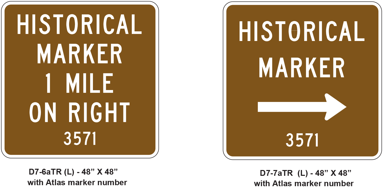
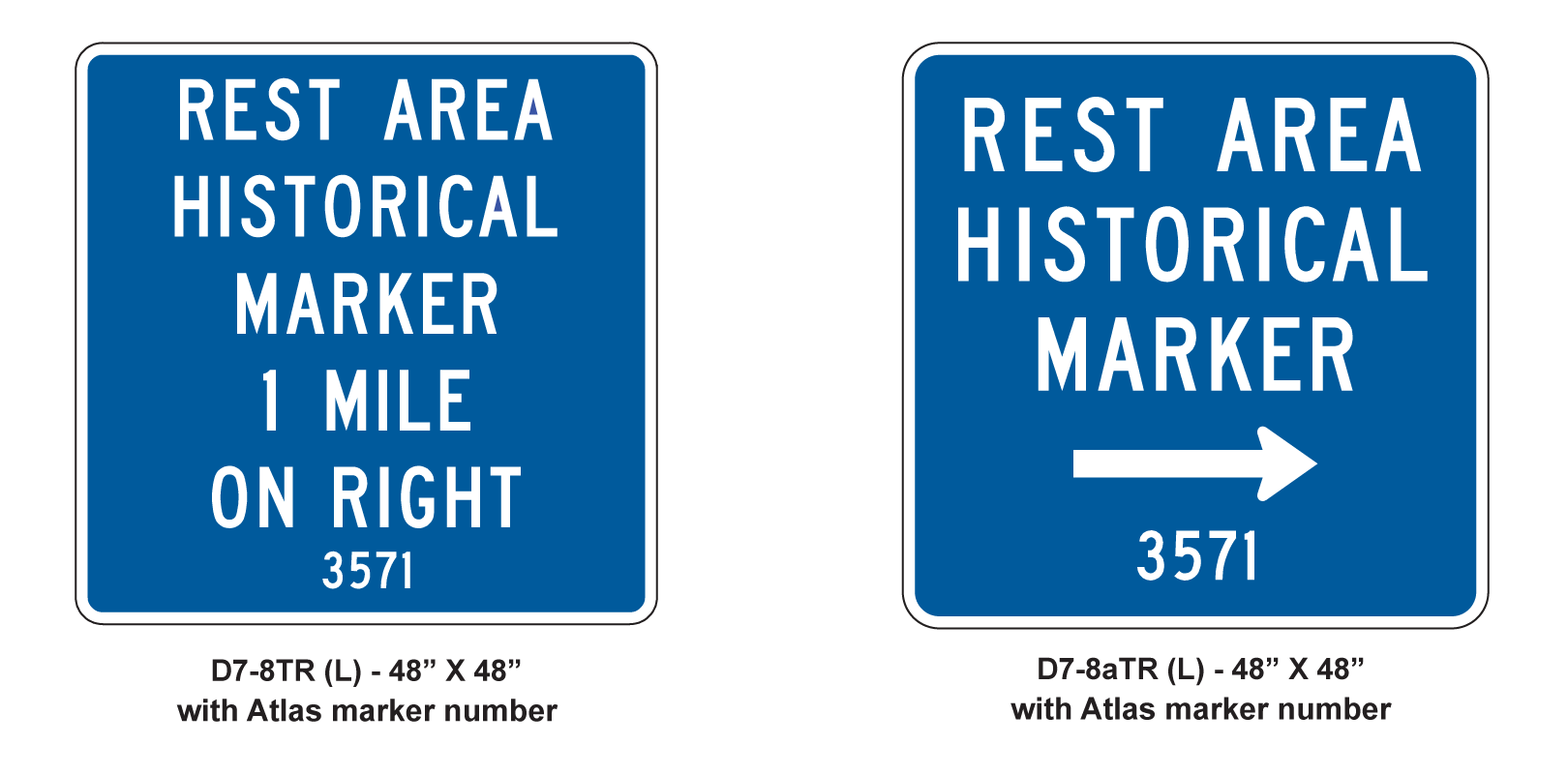
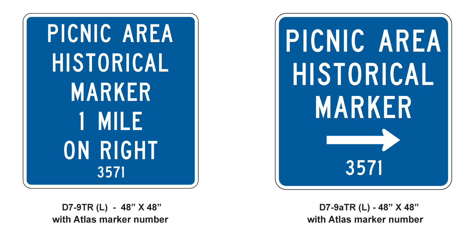
Details of various advance and directional historical marker guide signs with Atlas marker numbers are shown in Figure 7‑12 through Figure 7‑14.
Figure 7-12. Advance and directional historical marker guide signs with Atlas marker numbers. Colors: legend - white (retroreflective); background - brown (retroreflective).
Figure 7-13. Advance and directional rest area historical marker guide signs with Atlas marker numbers. Colors: legend - white (retroreflective); background - blue (retroreflective)
Figure 7-14. Advance and directional picnic area historical marker guide signs with Atlas marker numbers. Colors: legend - white (retroreflective); background - blue (retroreflective)


