Section 7: Additional Considerations
This section contains various topics that should be considered during transportation design in a coastal area. These topics include:
- Anchor: #HAKUYTIS
- Topography and bathymetry Anchor: #BKHVFUVL
- Construction materials Anchor: #DNUBMUEM
- Design elements
Topography and Bathymetry
Topographic and bathymetric information provide the basis for equation inputs, such as water depth, beach slopes, and land elevations. These data are also valuable when creating numerical modeling domains to determine various coastal processes at a particular location. The following discussion focuses on evaluating and acquiring existing data for these purposes, but there are locations or projects that may require new data collection. In general, the entire Texas coastal region has had LiDAR data collected since 2007 that provide topographic coverage of high resolution, that would only need to be supplemented by local survey for design work. Bathymetry is much less recently or accurately collected along the Texas coast. Readily available bathymetry datasets would be sufficient for Level 1 or possibly Level 2 analyses, but for Level 2 analyses where water depths at or near the project site are critical for coastal design calculations and any Level 3 analysis, local bathymetric survey would be required to supplement the regional or statewide datasets.
In many cases, existing high-resolution datasets, such as LiDAR terrain or bathymetry data, will be readily available. When used in combination with site specific field surveys necessary for project design, they can provide the information necessary to understand historical trends of elevation changes in the project area, including in the surrounding submerged environment when bathymetric field survey is collected. In locations where LiDAR or other high-resolution elevation/bathymetric datasets already exist, the designer must determine whether and how the datasets can be used in the project. The following conditions should be considered:
- Anchor: #WPYBLLUV
- Date of Collection. While there is not a specific age requirement for elevation data, coastal areas are dynamic, and preference should be given to more recent data. If a known area within an older dataset has experienced a terrain disturbance since the data collection (such as a hurricane that caused coastal erosion), new data may be collected within this smaller area and the older dataset may be used for the remainder of the area. Anchor: #LGVLLYPO
- Metadata. All terrain datasets should have accompanying metadata. This information should include collection and processing information, as well as the vertical and horizontal accuracy of the dataset. If metadata is missing, it may be necessary to contact the agency responsible for data collection to obtain the metadata or to perform horizontal or vertical accuracy tests on an area of known topography to determine validity. Anchor: #RLYNUDGL
- Accuracy. Generally, data with the highest vertical accuracy is most appropriate for use. However, other factors such as age, extent, resolution and availability of the dataset should also be considered. For example, if physical changes have occurred to an area during the intervening years within a dataset with very high vertical accuracy, the reported vertical accuracy may be rendered meaningless for the area. If possible, comparison of multiple datasets for the area will highlight the most accurate in terms of representing the terrain.
Topographic and Bathymetric Data Sources
- Anchor: #YOLWOEHX
- Project Specific Surveys — Depending on the availability and age of publicly available bathymetric and topographic data, project specific surveys may be necessary as noted at the beginning of this section. Site specific surveys are particularly important in areas with recent erosion or accretion that may not be apparent in older, publicly available data, but is identified by local stakeholders or TxDOT operations staff. Anchor: #BJODEFKB
- Texas Natural Resources Information System (TNRIS) — TNRIS serves as the geospatial data clearinghouse for the state of Texas. They maintain publicly available datasets for Texas-based LiDAR as well as a statewide coastal bathymetry dataset. This is the primary topographic and bathymetry data source for TxDOT projects in the coastal zone. https://data.tnris.org/ Anchor: #MMKLCWCJ
- USACE Hydrographic Surveys — The USACE Galveston District performs routine channel-condition surveys along the federally-maintained ship channels and the Gulf Intracoastal Waterway. The age, resolution, and format of these data vary by location. http://www.swg.usace.army.mil/Missions/Navigation/HydrographicSurveys/ Anchor: #QHBAHCNG
- NOAA National Centers for Environmental Information (NCEI) — Formerly the National Geophysical Data Center (NGDC). The NCEI provides a map interface that displays the location of publicly available bathymetric data. The age, resolution, and format of these data vary by data type, source and location and can be found at https://www.ngdc.noaa.gov/. Also see https://www.ngdc.noaa.gov/mgg/bathymetry/estuarine/ Anchor: #HYXPAUAL
- U.S. Geological Survey: The National Map — USGS provides both existing and historical topographic information via The National Map. The age, resolution, and format of these data vary by source and location. USGS provides a national level resource to supplement TNRIS, if necessary. http://nationalmap.gov/
Construction Materials in Transportation Infrastructure
This section identifies best practices in materials selection that may be influenced by coastal processes. The material guidance included in this section would apply to various TxDOT infrastructure projects, including pavements, facilities, ferries, drainage structures, bridges, etc. Besides typical design factors such as traffic loading and subgrade soil characteristics, infrastructure located within coastal areas can be subject to additional effects such as saltwater intrusion, uplift from storm surges, and rapid drawdowns.
Saltwater Intrusion
Infrastructure’s exposure to saltwater can lead to serious damage and drastically reduce the design life of infrastructure if not considered in the design. It is recommended the designer consult guidance on material selection for infrastructure that could encounter this environment.
Infrastructure
Infrastructure including, but not limited to, drainage structures, bridge piles, and guard rails may need to consider saltwater influence when choosing the most appropriate material. For example, for bridge piles located in saltwater environments, marine grade steel is recommended (USACE New Orleans District, 2012).
The U.S. Army Corps of Engineers provides guidance on materials selection for various infrastructure and coastal conditions.
Pavements
Similar to all typical pavements, coastal pavements can be categorized into rigid and flexible pavement types. Rigid pavements are composed of a stiff Portland Cement Concrete (PCC) surface, while flexible pavements consist of bendable surfaces, such as asphalt. Common to both pavement types are base courses and subbase courses, consisting typically of aggregate materials. All pavement sections are supported by a subgrade, which usually entails the existing ground formation. Pavement type, including future maintenance (of joints, materials, etc.), will primarily be determined by the transportation design (e.g., loading, traffic), but coastal impacts should also be considered.
The general impact of saltwater intrusion on pavements is the effect of corrosion, and pavement materials must be selected to counteract this factor. For PCC pavements, the primary element susceptible to corrosion is any steel reinforcement contained within, as well as any steel dowels used at the joints. One way to afford corrosion protection is by using corrosion-resistant materials for reinforcement and dowels. Alternatively, plastic fiber reinforcement, which is not subject to oxidation, may be used as a form of reinforcement. Improvements to the PCC mix design itself can also provide enhanced protection from saltwater, such as by using sulfate resistant cement and by reducing the permeability of concrete through the use pozzolans, including fly ash, slag cements, and silica fume. Another consideration during pavement design is increasing the concrete thickness over reinforcing bars to provide additional protection.
Asphalt surfaces are not significantly affected by saltwater corrosion. Generally, a dense-graded asphalt mixture with low porosity is recommended for pavement construction. A soft asphalt binder is preferred so that a longer service life to hardening under saline attack is obtained. Additionally, eliminating the use of moisture-susceptible aggregates and anti-stripping agents can minimize moisture damage of the asphalt mixture in general.
Construction Materials Data Sources
- Anchor: #CQLGNREX
- American Concrete Institute (ACI) — ACI 357R-84, Guide for the Design and Construction of Fixed Offshore Concrete Structures (Chapter 2, Materials and Durability). Anchor: #OYKHWKJB
- The Aberdeen Group — Designing Concrete for Exposure to Seawater, Bruce A. Suprenant, Publication # C910873, 1991. Anchor: #WFEOYCWM
- Federal Highway Administration
(FHWA) —
- Anchor: #NQJLKUUB
- Techniques for Reducing Moisture Damage in Asphalt Mixtures, FHWA/TX-85/68+253-9F, November 1984. Anchor: #DKNRYABG
- Advanced High-Performance Materials for Highway Applications: A Report on the State of Technology, FHWA-HIF-10-002, October 2010.
Anchor: #NRLSTNHQ - U.S. Army Corps of Engineers New Orleans District — Hurricane and Storm Damage Risk Reduction System Design Guidelines: Chapter 5.0 - Structures. https://www.mvn.usace.army.mil/Portals/56/docs/engineering/HurrGuide/Ch5.pdf
Storm Surge and Drawdown Protection
For protection of pavements from the effects of storm surge uplifts and rapid draw downs, the use of a treated base, such as cement-treated base or asphalt-stabilized base, is most effective in waterproofing PCC pavements. For flexible asphalt pavements, the critical factor is to utilize permeable aggregate materials in the base and subbase layers under the pavement that can tolerate and convey seawater surges. To accomplish this, the aggregate layers under the pavement must be of sufficient thickness (as well as be resistant to saltwater corrosion) to convey the surge through each layer and not cause the surge to back up and produce uplift in the impermeable pavement surface constructed overtop of it.
Alternatively, a permeable asphalt surface may be considered under load conditions that warrant its use. Typically, the asphalt layer lies on top of an aggregate drainage layer that drains into underdrains that lead to roadside ditches or are conveyed into an overall storm drainage system for the roadway.
Where coastal pavements are supported by subgrades of low strength, or for pavements that are subject to water level changes, the use of geotextile grids or fabrics to reinforce subgrades and bases is recommended. The major actions of geotextiles are separation of materials and reinforcement. Benefits afforded by geotextiles used in subgrade and base layers include base and subgrade restraint, lateral restraint, and membrane-type support of the pavement system.
Storm Surge and Drawdown Protection Data Sources
- Anchor: #BXOVDYCU
- Federal
Highway Administration —
- Anchor: #YUQBANNS
- Hydraulic Engineering Circular No. 25, Highways in the Coastal Environment, 2nd Edition, FHWA NHI-07-096, June 2008 (update anticipated in Summer 2019). Anchor: #OQMQSXHC
- Hydraulic Engineering Circular No. 25 – Volume 2, Highways in the Coastal Environment: Assessing Extreme Events, FHWA-NHI-14-006, October 2014. Anchor: #JMTNGNJT
- Hydraulic Engineering Circular No. 17, Highways in the River Environment- Floodplains, Extreme Events, Risk, and Resilience, 2nd Edition, FHWA-HIF-16-018, June 2016.
Anchor: #SCMRRJAR - Handbook of Geosynthetics, Geosynthetic Materials Association (GMA), 2010. Anchor: #PJUYNWMB
- The Handbook of Groundwater Engineering (Chapter 37: Geosynthetics), 2nd Edition, Zornberg, J.G., and Christopher, B.R., 2007.
Design Elements
Coastal structures can include roadways and bridges, but also include structures that promote coastal defenses with the objective of minimizing shoreline erosion or protecting against nearshore processes. Some of these coastal structures were discussed in Section 5. The general types and functions of coastal structures and roadway design, bridge design, and site-specific design conditions are discussed below as part of planning a coastal design.
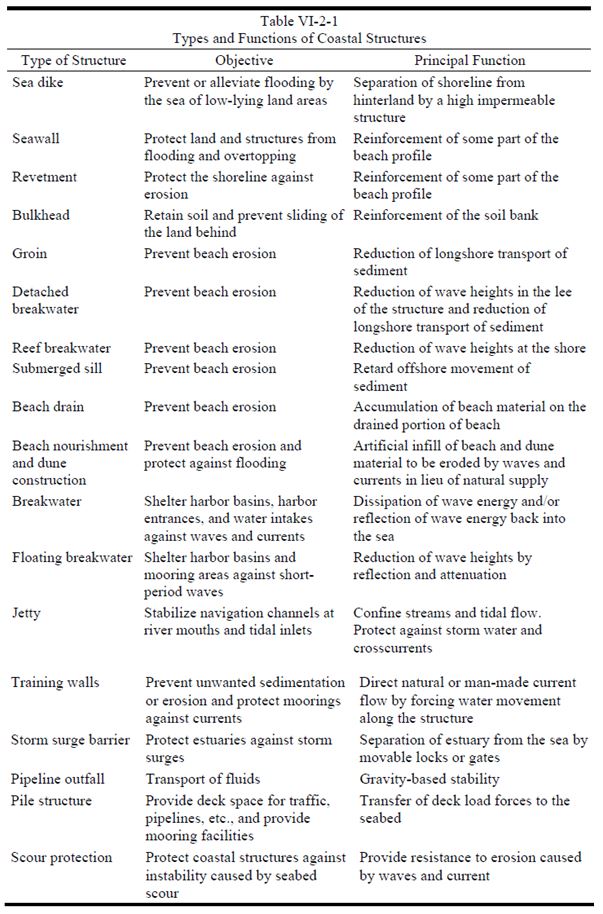
Depending on the site conditions and the nearshore processes at play, there are several types of coastal structures that can be designed to protect and mitigate concerns in coastal areas. Coastal structures shown in Figure 15-34 below can be considered in combination for a complementary design that works to best address multiple, site specific concerns.
Figure 15-34. Table VI-2-1 from Coastal Engineering Manual (USACE, 2002).
Coastal Roadway Design Considerations
Roadway design in coastal environments can begin similar to upland roadway design. The roadway geometry and layout should consider, when applicable, locations that have minimal impacts from nearshore processes. The roadway elevation should consider the design elevation (Section 4) to include any additional height requirements to avoid overtopping or wave splash impacts on the pavement structure. If raising the grade is not preferred or possible, other techniques mentioned in Section 5 for overwash should be applied to protect the roadway during overwash conditions. If the roadway is adjacent or close to areas where wave action and storm surge can impact the structure, protection of the embankment should be considered.
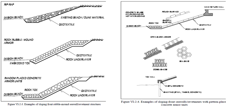
Hard structures often considered as a complement in roadway design from Figure 15-34 above include revetments and seawalls. Revetments and seawalls start with similar design considerations, primarily wave concerns. Revetments are onshore structures with the principal function of protecting the shoreline from erosion. Revetment sizing was discussed with regards to design wave height in Section 3 and Hudson’s formula for particle sizing in Section 5. Seawalls, also discussed in Section 5, are used to protect promenades, roads, and buildings placed seaward side of the beach on the slope next to the top of the dune. The USACE CEM provides typical cross sections and layouts as well as example design problems for these structures, as seen in Figure 15-35 below.
Figure 15-35. Seawall and Revetment Guidance from Coastal Engineering Manual (USACE, 2002)
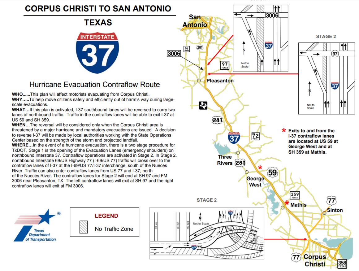
Although there is always some risk associated with the design of coastal roadways, significant risks are those classified as having a probability of catastrophic failure with loss of life, or when a road is the only vehicular egress route available to a community. Roadways designated as evacuation routes or sole egress should be designed to a higher standard; for example, applying a higher freeboard than AASHTO requires would allow efficient and effective inland evacuation. For instance, it is common practice to design the roadway elevation of an evacuation corridor to be at or above a 100-year return period design elevation. Similarly, the evacuation road corridor may also be designed to survive overwashing during the storm event to minimize road damage and thus allow post-storm emergency first responders and supplies to quickly re-enter an affected area. Evacuation corridors are also commonly designed with additional capacity (including options for contraflow) to remove bottlenecks, allowing safe transportation of people and goods in times of excessive demand on the roadways (Figure 15-36).
Figure 15-36. I-37 Contraflow Plan Corpus Christi.
Coastal Bridge Design Considerations
Hydraulic bridge design typically starts with an assessment of hydraulic capacity and evaluation of design elevation for the low chord. Other design considerations include bridge length, span arrangement, abutment location, and pier arrangement. The process for creating a design elevation is discussed in Section 4. Once the design elevation is determined, the proposed bridge design can be evaluated for environmental impacts, changes in nearshore processes, and can be structurally designed to withstand the various coastal loads. Hydraulic considerations vary between riverine and coastal scenarios, with many designs requiring consideration of both, or even cumulative effects, for proper assessments.
One type of hard coastal structures listed in the previous table and described in detail in the USACE CEM is pile structures. The most common pile structures in coastal engineering are bridge piers. Pile structures are designed based on the bearing capacity and settlement characteristics of the seabed. With coastal bridges, the substructure and how it interacts with the superstructure and deck can be quite complex. In addition to the bridge deck and piers carrying loads from traffic, the pile structures of the piers are exposed to loads from waves and currents that can result in scouring. Where scour analyses or geotechnical reports indicate potential instability at pile structures, scour protection can be placed. Scour protection often consists of rock bed on a stone or geotextile filter; however, specialty designed concrete block and mattress systems are also used. Scour protection was discussed in Section 5 with regards to methods to determine scour depth, along with recommended resources for determining countermeasures. In addition, as mentioned in Section 5, both FHWA HEC-25 and the USACE CEM discuss coastal scour and scour protection.
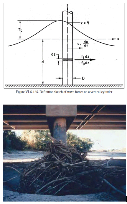
Many variables can be important in determining forces on piles subjected to wave action. Besides scour potential, wave and current load forces on the piles should be reviewed, if applicable, for structural instability. Although the analysis can be quite complex (refer to HEC-25 and the CEM for guidance), there are some factors that can be taken in to account during design that help reduce impacts. Some factors the designer can control include: pile diameter, pile shape, pile roughness, and pile orientation to the flow field. Factors that impact pile wave forces but are not controllable by the designer include: wave height, water depth, and wave period/wavelength. Figure 15-37 below shows the wave forces on a vertical cylinder.
Figure 15-37. Coastal Engineering Manual Vertical Wave Forces on a Vertical Cylinder (USACE, 2002)
When possible, or when determined as part of a project scope, the site-specific wave forces on the bridge pier design should be evaluated. When this is not possible or other standards are used for pier construction, there are recommendations that can help minimize wave forces. Rounded piles have beneficial structural properties and have less resistance to flow than rectangular piles. Spacing of piles along a bent can also impact the flow field. For multiple columns skewed to the flow direction, the scour depth can be significantly affected by the spacing between the columns. When possible, rounded, well-spaced piles aligned to the flow field can reduce risk of potential scour and limit the bridge backwater.
Additional Coastal Design Considerations
Additional design considerations include geotechnical, multimodal traffic, utilities, environmental, community access, and design aesthetics.
When designing a roadway, a geotechnical investigation is required to evaluate the anticipated pavement design and to consider potential failure mechanisms from nearshore processes, like overwashing and wave action. In both bridge and roadway design, the interaction between coastal infrastructure and underlying soil is a critical aspect of project performance. In addition, a bridge scour analysis could not be conducted without this investigation since the channel bed particle size and behavior is at the core of the scour equations.
Environmental regulations and identified environmental concerns should be reviewed for the project site prior to design. Addressing environmental concerns would involve a review of potential impacts that may result in ecological changes, even those changes that may be beneficial. Permits, consultations, and/or coordination with resource and regulatory agencies may be required for potential impacts to the water itself, navigability of the waterway, state and federally protected species, archeological and historic resources, and many other environmental resources. Permits, consultations, and coordination with regulatory and resource protection agencies can require increased environmental review of anticipated impacts from a proposed design and can be expected to increase the cost and timeframe required to deliver a project. Working closely with the Environmental Affairs Division and District environmental staff to identify environmental constraints and permitting pathways early in design will ultimately benefit project delivery.
When planning for new or improved infrastructure in a coastal area, especially a bridge, the volume of traffic is often a concern. Also, a potential concern is the ability for traffic, particularly aquatic vessel traffic, to pass under the bridge with sufficient vertical clearance in areas like the Gulf Intracoastal Waterway, which are travel ways for very large barges. There may also be existing or future utilities that need to be considered in the allowable vertical clearance for roadway and bridge traffic, in bridge design loads, or in placement of piers to avoid subsurface conflicts.
When designing new or improved coastal infrastructure, the existing condition should be evaluated for community needs. For instance, if a new or improved roadway is being designed and a new revetment is needed along the seaward side, the revetment may impact recreation or community access to the shoreline. Areas around coastlines are very often used for fishing, kayaking, swimming, and other activities. An evaluation should be performed to determine if the proposed infrastructure will impact the current community use of the coastline or region.
Proposed coastal infrastructure projects could have potentially significant impacts related to effects on a scenic vista or degradation of the existing visual character of a project area. Hard coastal structures are beneficial for erosion control but can often create aesthetic or shoreline access concerns for the community. Community engagement and feedback on the proposed design should be considered to ensure infrastructure projects can meet both design criteria and local stakeholder needs.
Living Shorelines
Transportation systems within the coastal zone are subject to highly dynamic systems and are susceptible to changing water levels, storm surge, currents, and wave attack. Because these forces are often very large and varied, identifying design techniques that can mitigate and adapt to meet future risks is valuable to extending project life cycles. Living shoreline techniques involve combining ecologically-based mitigation techniques, such as coastal vegetation, with hardened solutions, such as breakwaters or revetments, to create strong, but also more adaptable systems. Living shorelines can provide long-term risk mitigation due to their more dynamic nature, as they incorporate natural processes, such as sedimentation and vegetation growth, that can rise or adapt—to some extent-- with long-term changes such as relative sea level rise.
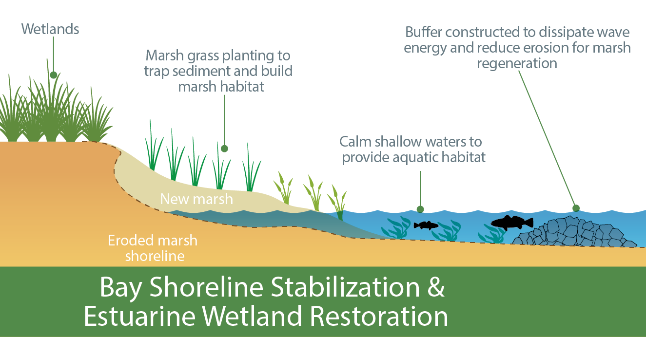
Incorporating local natural elements, particularly vegetation, can lead to a more resilient transportation structure that includes nature-based buffers between the transportation system and the dynamic forces of coastal waters. In addition to coastal vegetation, these designs can include sediment capture or shoreline stabilization features along beaches or other shoreline systems. Such natural elements are more dynamic and adaptable to nearshore processes, which can be beneficial in adapting to changing shoreline conditions and water levels. For projects located near shorelines, it is recommended to evaluate living shoreline techniques for cost effective applicability to promote project longevity and risk mitigation over traditional hard armoring techniques. Examples of shoreline stabilization relevant to living shoreline techniques are shown in Figure 15-38 below. Marsh grasses and nearshore man-made oyster reefs submerged breakwaters, much like the example below, have been planted and constructed along Broadway Street in Little Bay, providing roadway infrastructure in Aransas County with a more resilient long-term solution to erosive coastal forces.
Figure 15-38. Living Shoreline Example Section.
Additional living shoreline references include NOAA Habitat Blueprint and the Texas Coastal Resiliency Master Plan.
Anchor: #i1027573Government Policies and Regulations Regarding Coastal Projects
Refer to Chapter 2 for general state and federal regulations and policies. Below are plans, policies, and regulations that apply to most projects occurring in coastal environments.
Federal
- Anchor: #JLQOUEKU
- USACE. The
USACE issues permits and authorizations for discharges of dredged
or fill material into waters of the U.S., which includes a variety
of waters and wetlands. Typical “fill” impacts such as shoreline
stabilization, drainage outfalls, bridge piers/bents, and other structures
in jurisdictional waters require permitting, and most likely compensatory
mitigation. In general, the greater the impacts, the longer, more
complex, and more expensive the path may be to obtain USACE approval
before construction can be initiated. USACE regulations require
consideration of direct and indirect physical effects of future
sea level change across the project life cycle for managing, planning,
engineering, design, constructing, and maintaining USACE projects
located in and near the coastline.
The USACE also must grant permission for the alteration, occupation, or use of a USACE civil works project, for example to build a bridge or road that crosses a USACE-owned property or easement (levees, dams, reservoirs, flood mitigation areas, sea walls, bulkheads, etc.). The USACE supports levee certification decisions for the NFIP administered by FEMA. If USACE permission is required, it must be granted before the USACE can issue any other type of permit or authorization.
TxDOT maintains a funding agreement with the USACE Galveston District for expedited review and technical assistance. Contact the Environmental Affairs Division and District environmental staff to assist with USACE permits and authorizations.
Anchor: #XJIGFKPM - USACE and U.S. Coast Guard. Crossings
of rivers, estuaries, and bays considered to be navigable waterways
are regulated by the U.S. Coast Guard (USCG) and the USACE. For projects
involving construction of bridges over navigable waterways, a permit
or authorization may be required from the USCG and/or the USACE.
The USCG reviews and permits bridges and causeways over navigable waters, authorizes associated lighting and signals, and imposes conditions relating to construction, maintenance, and operation in the interest of public navigation. The USCG requires plans suitable for general public use in addition to standard TxDOT plans. Refer to the USGC Bridge Permit Application Guide for permitting procedures and guidance. Environmental Affairs Division and District environmental staff can assist with USCG permits and authorizations, including those involving the sequential relationship with USACE authorizations and permits. Early coordination with the USCG is recommended; however, the final permit application may not be submitted until final design (i.e., 90 percent plans), and permitting may take six months or more.
Anchor: #QKHWHERK - U.S. Fish and Wildlife Service
(USFWS) and National Marine Fisheries Service (NMFS). Coastal
highways traverse bays, estuaries, coastal wetlands, and beaches,
which support a diversity of habitats for a variety of threatened
or endangered plant and animal species. Each project must be assessed
for its potential to impact federally protected species and essential fish
habitat. Depending on anticipated impacts and the species involved,
coordination or consultation with the USFWS and the NMFS may be
required to permit or authorize the project. Contact the Environmental
Affairs Division and District environmental staff to assist with
protected species evaluations. All consultations with the USFWS
and the NMFS are conducted through the Environmental Affairs Division.
The USFWS also administers the Coastal Barrier Resources Act (CBRA), which discourages development in coastal areas that are vulnerable to hurricane damage and that host valuable natural resources by designating certain undeveloped coastal areas ineligible for most new federal expenditures and financial assistance. If the project includes any type or amount of federal funding and is located within designated areas, the project must be reviewed to determine if project activities qualify for an exception and if the project is consistent with the purposes of the CBRA. If the project qualifies for an exception, the determination must be approved though consultation with the USFWS. If the project does not qualify for an exemption, project activities are not eligible for federal funding under the CBRA. All CBRA consultations with the USFWS would be conducted through the Environmental Affairs Division.
State
- Anchor: #LHCGXJMJ
- Texas Parks & Wildlife Department (TPWD). TxDOT and TPWD have a Memorandum of Understanding (MOU) that outlines responsibilities for the protection of the natural environment. Under the MOU, TxDOT is required to assess projects for their potential to impact state-protected species and other protected or imperiled resources, and to coordinate certain types of projects. Assessments and coordination with TPWD are conducted and managed by District environmental staff with assistance from the Environmental Affairs Division. Coordination is conducted under the MOU with transportation liaisons in the TPWD Wildlife Habitat Assessment Program. Coordination with TPWD should occur as early as possible to capture and implement recommendations to minimize habitat impacts. Anchor: #NNBSVDLK
- Texas General Land Office (GLO),
Texas Coastal Resiliency Master Plan. The State of Texas
has not developed statewide regulations related to sea level rise
and coastal hazards. In March 2019, the GLO on behalf of the State
prepared a
Texas
Coastal Resiliency Master Plan to reduce the vulnerability
of the state’s coastal infrastructure and resources. The plan provides resiliency
goals for the state and a recommended set of prioritized projects
to support enhanced protection for the state’s coastline. During
project planning, the Texas Coastal Resiliency Master Plan should
be consulted to ensure the proposed roadway project is in alignment
with overall state resiliency goals.
The GLO also manages all state submerged lands (tidal and non-tidal). TxDOT is required to acquire easements from the GLO for all transportation projects that will acquire state-owned submerged lands. The identification of submerged lands and required easements is typically performed during project planning and is addressed during ROW acquisition.
