Section 4: Stream Stability Issues
Anchor: #i1017859Stream Geomorphology
Planning and location engineers should be conscious of fluvial geomorphology and request the services of hydraulics engineers to quantify natural changes and changes that may occur as a result of stream encroachments, crossings, or channel modifications.
Fluvial geomorphology and river mechanics are not new subjects; however, methods of quantifying the interrelation of variables are relatively recent developments. The theories and knowledge available today make it possible to estimate and predict various reactions to changes and, more importantly, to establish thresholds for tolerance to change.
Streams have inherent dynamic qualities by which changes continually occur in the stream position and shape. Changes may be slow or rapid, but all streams are subjected to forces that cause changes to occur. In these streams, banks erode, sediments are deposited, and islands and side channels form and disappear in time. The banks and adjacent floodplains usually contain a large proportion of sand, even though the surface strata may consist of silt and clay; thus, the banks erode and cave with relative ease.
Most alluvial channels exhibit a natural instability that results in continuous shifting of the stream through erosion and deposition at bends, formation and destruction of islands, development of oxbow lakes, and formation of braided channel sections.
The degree of channel instability varies with hydrologic events, bank and bed instability, type and extent of vegetation on the banks, and floodplain use.
The identification of these characteristics and understanding of the relationship of the actions and reactions of forces tending to effect change enables the design engineer to estimate the rates of change and evaluate potential upstream and downstream effects of natural change and proposed local channel modifications.
The potential response of the stream to natural and proposed changes may be quantified with the basic principles of river mechanics. The design engineer must understand and use these principles to minimize the potential effect of these dynamic systems on highways and the adverse effects of highways on stream systems.
Non-alluvial channels have highly developed meanders in solid rock valleys and may be degrading their beds. An example of such a stream is the Guadalupe River as it passes through the Edwards Aquifer recharge zone. Many mountain streams are classified as non-alluvial, and in these cases the design engineer may perform a hydraulic analysis utilizing rigid boundary theory.
Anchor: #i1017904Stream Classification
Figure 7‑1 illustrates the three main natural channel patterns: straight, meandering, braided, and their relationships to each other. For a more complete explanation of this classification system, see FHWA/RD-80/160 “Methods for Assessment of Stream Related Hazards to Highways and Bridges”, Shen, et. al, 1981.
Figure 7-1. Natural Stream Patterns
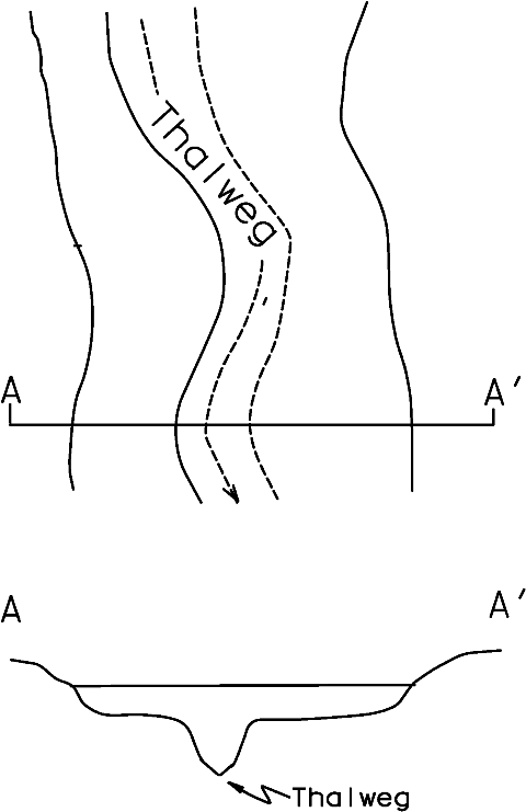
Straight Streams. A stream is classified as straight when the ratio of the length of the thalweg (path of deepest flow; see Figure 7‑2) to the length of the valley is less than 1.05. This ratio is known as the sinuosity of the stream. Degrees of sinuosity are illustrated in Figure 7‑3.
Figure 7-2. Thalweg Location in Plan View and Cross Section
Figure 7-3. Various Degrees of Sinuosity
Straight channels are sinuous to the extent that the thalweg usually oscillates transversely within the low flow channel, and the current is deflected from one side to the other. The current oscillation usually results in the formation of pools on the outside of bends while lateral bars, resulting from deposition, form on the inside of the bends as shown in Figure 7-1, diagrams 2 and 3b.
Straight reaches of alluvial channels may be only a temporary condition. Aerial photography and topographic maps may reveal former locations of the channel and potential directions of further movement.
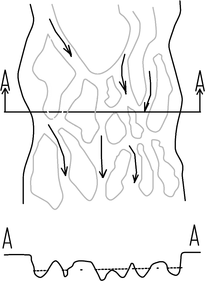
Braided Streams. Braiding is caused by bank caving and by large quantities of sediment load that the stream is unable to transport (see Figure 7‑4). Deposition occurs when the supply of sediment exceeds the stream’s transport capacity. As the streambed aggrades from deposition, the downstream channel reach develops a steeper slope, resulting in increased velocities. Multiple channels develop on the milder upstream slope as additional sediment is deposited within the main channel.
Figure 7-4. Plan View and Cross Section of a Braided Stream
The interlaced channels cause the overall channel system to widen, resulting in additional bank erosion. The eroded material may be deposited within the channel to form bars that may become stabilized islands. At flood stage, the flow may inundate most of the bars and islands, resulting in the complete destruction of some and changing the location of others. A braided stream is generally unpredictable and difficult to stabilize because it changes alignment rapidly, is subject to degradation and aggradation, and is very wide and shallow even at flood stage.
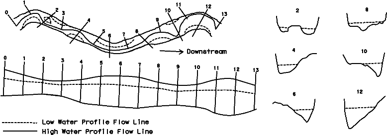
Meandering Streams. A meandering stream consists of alternating S-shaped bends (see Figure 7‑5). In alluvial streams, the channel is subject to both lateral and longitudinal movement through the formation and destruction of bends.
Bends are formed by the process of erosion and sloughing of the banks on the outside of bends and by the corresponding deposition of bed load on the inside of bends to form point bars. The point bar constricts the bend and causes erosion in the bend to continue, accounting for the lateral and longitudinal migration of the meandering stream (Figure 7‑5).
Figure 7-5. Plan View and Cross Section of a Meandering Stream
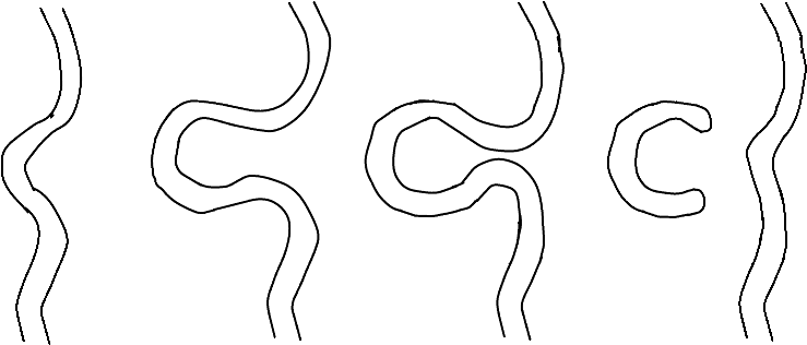
As a meandering stream moves along the path of least resistance, the bends move at unequal rates because of differences in the erodibilty of the banks and floodplain. Bends are ultimately cut off, resulting in oxbow lakes (see below).
Figure 7-6. Migration Leading to Formation of Oxbow Lake
After a cutoff is formed, the stream gradient is steeper, the stream tends to adjust itself upstream and downstream, and a new bend may develop. Compare aerial photographs taken over a period of years to estimate the rate and direction of the meander movement. Local history may also help to quantify the rate of movement.
Anchor: #i1018021Modification to Meandering
Modification of an alluvial channel from its natural meandering tendency into a straight alignment usually requires confinement within armored banks because the channel may be very unstable. Straightening meandering channels can result in steeper gradients, degradation, and bank caving upstream as the stream attempts to reestablish equilibrium. The eroded material will be deposited downstream, resulting in reduced stream slopes, reduced sediment transport capacity, and possible braiding. When a channel is straightened without armor banks, the current will tend to oscillate transversely and initiate the formation of bends. Eventually, even protected straight channel reaches may be destroyed as a result of the natural migration of meanders upstream of the modified channel.
Anchor: #i1018031Graded Stream and Poised Stream Modification
Graded streams and poised streams are dynamically balanced, and any change altering that condition may lead to action by the stream to reestablish the balance. For example, if the channel gradient is increased, as occurs with a cutoff, the sediment transport capacity of the flow is increased and additional scouring results, thereby reducing the slope. The transport capacity of the downstream reach has not been altered; therefore, the additional sediment load carried downstream is deposited as a result of upstream scour. As the aggradation progresses, the stream slope below the deposition is increased, and the transport capacity is adjusted to the extent required to carry the additional material through the entire reach. This process continues until a new balance is achieved, and the effect could extend a considerable distance upstream and downstream of the cutoff.
Anchor: #i1018041Modification Guidelines
It may be necessary to modify a stream in order to make it more compatible with the highway facility and the physical constraints imposed by local terrain or land use. The modifications may involve changes in alignment or conveyance. Changes may be necessary to accommodate the highway requirements, but they must be evaluated to assess short-term and long-term effects on the stream system.
Background data on the existing stream should be available from previously completed planning and location studies, and a preliminary highway design should be available in sufficient detail to indicate the extent of required channel modifications.
Certain types of streams may have a very wide threshold of tolerance to changes in alignment, grade, and cross-section. In contrast, small changes can cause significant impacts on sensitive waterways. An analysis of the tolerance to change may reveal that necessary modifications will not have detrimental results.
If you recognize detrimental effects, develop plans to mitigate the effects to within tolerable limits. You can enhance certain aspects of an existing stream system, often to the economic benefit of the highway. The following are examples of ways to enhance stream systems:
- Anchor: #UMJKMJGH
- Control active upstream headcutting (degradation due to abrupt changes in bed elevation) with culverts or check dams so that many hectares of land along the stream banks will not be lost and the highway facility will be protected from the headcutting. Anchor: #MLGNGINI
- Coordinate and cooperate with fish and wildlife agency personnel, adapt or modify stabilization measures necessary to protect the highway while improving aquatic habitat.
Realignment Evaluation Procedure
The realignment of natural streams may disrupt the balance of the natural system. When evaluating stream modifications, use the following procedure:
- Anchor: #MKGLMLFN
- Establish slope, section, meander pattern and stage-discharge relationship for present region. Anchor: #OKHMGMNI
- Determine thresholds for changes in the various regime parameters. Anchor: #HELIJELM
- Duplicate the existing regime, where possible, but keep within the established tolerances for change, where duplication is not practical or possible.
Stream realignment may occasionally decrease channel slope; more often, the modification will increase the channel gradient. A localized increase in channel slope may introduce channel responses that are reflected for considerable distances upstream and downstream of the project.
Anchor: #i1018108Response Possibilities and Solutions
Increased Slope. The following are possible responses to increased slope:
- Anchor: #LKLHILGL
- The stream response may be in the form of a regime change from a meandering to a braided channel, or sediment transport through the steepened reach may be increased enough to cause degradation upstream of the realignment and aggradation downstream. Anchor: #LGMHJLJG
- Banks may become unstable and require structural stabilization measures to prevent erosion. Anchor: #JINNMNFE
- Tributary channels entering the steepened main channel may be subject to headcutting, with deposition occurring at or downstream of the junction.
The following are possible solutions to increased slope:
- Anchor: #NPLFNIMG
- You may use grade control structures (such as check dams, weirs, or chutes) to minimize increases in gradient, provided there is some assurance that the normal meandering tendency of the channel will not bypass these structures in time. Anchor: #OEINEEHM
- If topography permits, use meanders to reduce the stream gradient to existing or threshold levels. These meanders may require stabilization to assure continued effectiveness and stability.
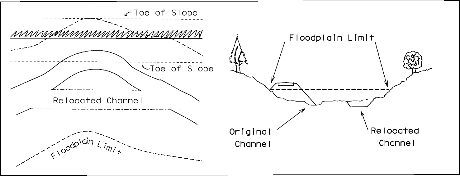
Encroachment. Highway locations or modifications in certain terrain conditions may result in an encroachment such as that illustrated in Figure 7‑7.
Figure 7-7. Highway Encroachment on Natural Streams and Stream Relocation
This type of channel realignment may require providing a channel of sufficient section to convey both normal and flood flow within the banks formed by the roadway and the floodplain. The low flow channel may require realignment, in which case a pilot channel could approximate the existing channel characteristics of width, depth, gradient, and bottom roughness. Where no pilot channel is provided, the average daily flow is likely to spread over a much wider section, and flow depth will be reduced in such a way that water temperature, pool formation, and sediment transport are adversely affected. These modifications may result in a braided channel condition and hamper the re-establishment of the natural aquatic environment.
Clearing of vegetation along stream banks may remove root systems that have contributed to bank stability. Clearing and grubbing reduces the bank and floodplain roughness and contributes to higher velocities and increased erosion potential for those areas. However, the limited clearing of adjacent right-of-way involved with transverse encroachments or crossings does not normally affect the overall conveyance capacity of a channel to any significance.
A water surface profile analysis is necessary to establish the stage-discharge relationship for channels with varying roughness characteristics across the channel. The Slope Conveyance Method of estimating stage-discharge relationships can be subject to significant error if the typical section used does not represent the actual conditions upstream and downstream of the crossing site. Therefore, the Standard Step Backwater Method is recommended. (See Section 6 for more details on these methods.)
Channel enlargement or cleanout through a limited channel reach is sometimes proposed in an effort to provide additional stream capacity. If the stage of the stream at the proposed highway site is controlled by downstream conditions, there can be limited or possibly no benefits derived from localized clearing.
Anchor: #i1018188Environmental Mitigation Measures
The potential environmental impacts and the possible need for stream impact mitigation measures should be primary considerations. (See Environmental Assessments in Section 2 for more information.) Mitigation practices are not generally warranted but may be mandated by the cognizant regulatory agency. As such, you may need to coordinate with Texas fish and wildlife agencies before determining mitigation. Consult the Environmental Affairs Division and the Design Division, Hydraulic Branch, to determine the need for mitigation when you deem stream modifications necessary.
Channel modifications may be necessary and also can provide environmental enhancement (see the previous Modification Guidelines subsection). Also, channel modifications that are compatible with the existing aquatic environment can sometimes be constructed at little or no extra cost.
There will be less aquatic habitat where a channel is shortened to accommodate highway construction. This not only decreases the aquatic biomass, but also reduces the amount of surface water available for recreation and sport fishing. Estimate the significance of this effect by comparing the amount of surface water area, riparian and upland wetland area, and stream length that will be lost with the existing amount in the geographic area. If there will be a loss, particularly of wetlands, resource and regulatory agencies may raise objections in light of the national “no net loss” policy currently prevailing. In some instances, such habitat loss may be acceptable when combined with mitigation measures, but such measures should prevent habitat damage beyond the channel change limits.
Enhancement of the channel may be accomplished during stream reconstruction at little additional cost, and perhaps at less cost where reconstruction is essential to the needs of the highway project. It may even be possible to reconstruct the surface water resource in one of the following manners that eliminates an existing environmental problem:
- Anchor: #TGKIJHFN
- incorporating sinuosity into a straight stream reach Anchor: #LEFJMGMM
- relocating the channel to avoid contamination from minerals or other pollution sources Anchor: #MLKLFGJK
- adjusting flow depth and width to better utilize low flows Anchor: #OJFMIGGI
- providing an irregular shaped channel section to encourage overhanging bank Anchor: #GGKNLFNH
- improving the riparian vegetation.
The most common practices are using a drop-type grade control structure (check dam), maintaining the existing channel slope, and increasing the channel change length by constructing an artificial meander.
Culverts can provide another alternative similar to using drop structures. You can increase the culvert flowline slope to accommodate the elevation difference caused by shortening a channel. The increased erosion associated with steep culverts is localized at the outlet that can be protected.
Simulate the existing channel cross section if it is relatively stable, has low flow depths and velocities, or has adequate minimum flow requirements.
Determine the cross-sectional shape by hydraulically analyzing simple and easy to construct shapes that approximate the preferred natural channel geometry. The analysis generally compares the stage-discharge, stage-velocity, and stage-sediment relationships of the natural channel with the modified channel.
Stream relocations may temporarily impair water quality. The problem is primarily sediment-related, except for those rare instances where adverse minerals or chemicals are exposed, diverted, or intercepted. With a channel relocation, the new channel should be constructed in dry conditions wherever possible. Following completion, the downstream end should be opened first to allow a portion of the new channel to fill as much as possible. Next, the upstream end should be opened slowly to minimize erosion and damage to habitat mitigation.
Where the channel relocation interferes with the existing channel, it may be desirable to construct rock and gravel dikes or to use other filtering devices or commercially available dikes to isolate the construction site, thereby limiting the amount of sediment entering the water.
Anchor: #i1018272Countermeasures
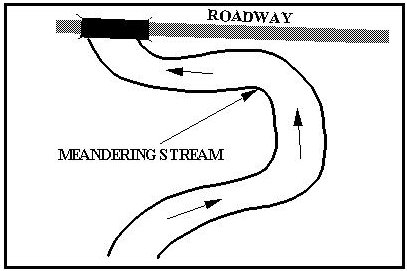
Many streams have a strong propensity to meander. The sinuosity of the main channel is a general characteristic of a stream and can vary with the discharge and the type of soil that the stream passes through. The erosive force of the stream water forms meanders as it undercuts the main channel bank. The bank support is lost and material caves into the water to be deposited downstream. As the erosion on the outer bend of the meander migrates in a downstream direction, material from upstream deposits on the inside of the bend. This progression of stream meandering can have serious effects on highway crossings. This migration often threatens approach roadway embankment and bridge headers such as shown in Figure 7‑8.
Figure 7-8. Meandering Stream Threatening Bridge and Approach Roadway
In order to protect the roadway from the threat of meanders, yet remain synchronous with nature, it is important to devise countermeasures that are environmentally sound, naturally acting, economically viable, and physically effective.
Possible countermeasures include the following:
- Anchor: #FFEKKKKF
- Bridge lengthening -- With reference to the example given in Figure 7‑8, lengthening the bridge may not always be cost-effective as a countermeasure to the damage potential from the meander. In this example, the natural meandering course of the river threatens both the bridge and the approach roadway. Anchor: #UHIJLEEN
- Bridge relocation – In extreme situations, it may be necessary to relocate the bridge. Generally, it is good practice to locate the bridge crossing on a relatively straight reach of stream between bends. Anchor: #MFJFMLLH
- River training or some type of erosion control – River training or some type of erosion control may be more effective and economical. Designers have used several measures and devices successfully in Texas to counter the effects of serious stream meandering. Anchor: #KMGGJLMG
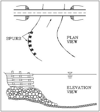
- Linear structures -- When it is not practical to locate the bridge on a relatively straight reach of stream, countermeasures such as spur or jetty type control structures may be needed (see Figure 7‑9). These are sometimes referred to as linear structures, permeable or impermeable, projecting into the channel from the bank to alter flow direction, protect the channel bank, induce deposition, and reduce flow velocity along the bank.
Figure 7-9. Permeable Fence Spurs as Meander Migration Countermeasures
Control structures may or may not cause the typical cross section of flow in a meandering stream to become more symmetrical. For many locations, countermeasures may not be required for several years because of the time required for the bend to move to a location where it begins to threaten the highway facility. In other streams, however, bends may migrate at such a rate that the highway is threatened within a few years or after a few flood events. In such cases, the countermeasure should be installed during initial construction.
Anchor: #i1018341Altered Stream Sinuosity
In some instances, stabilizing channel banks at a highway stream crossing can cause a change in the channel cross section and may alter the stream sinuosity winding upstream of the stabilized banks. Figure 7‑10 illustrates meander migration in a natural stream. If sinuosity increases due to artificial stream stabilization, then meander amplitude may increase. Meander radii in other parts of the reach may become smaller and deposition may occur because of reduced slopes. The channel width-depth ratio may increase as a result of bank erosion and deposition. Ultimately, cutoffs can occur.
Figure 7-10. Meander Migration in a Natural Stream
Refer to Design of Spur-Type Streambank Stabilization Structures, FHWA/RD-84/101 and Stream Stability at Highway Structures, HEC-20, for further design considerations, guidelines, and procedures for the various types of stream stabilization and meander countermeasures used and recommended by the department.
Anchor: #i1018370Stabilization and Bank Protection
Highway embankments constructed within a floodplain may require stabilization to resist erosion during flood events. You may design and construct embankment stabilization with the initial roadway project where the need is obvious or the risk of damage is high. In other locations the following factors may warrant that installation of embankment stabilization to be delayed until a problem actually develops as follows:
- Anchor: #IKJGMGLJ
- economic considerations Anchor: #HHQGFJME
- availability of materials Anchor: #FPNFIMMJ
- probability of damage.
Highway channel stabilization measures are usually local in nature. Engineers design them primarily to protect the highway facility from attack by a shifting channel or where the floodplain adjacent to the facility is highly erodible.
If a highway location adjacent to a stream cannot be avoided, you should evaluate protective measures to determine the measure best suited to the situation. These alternatives may include channel change, roadway embankment protection, stream bank stabilization, and stream-training works.
Channel stabilization should be considered only when it is economically justified and one or more of the following basic purposes will be accomplished:
- Anchor: #HNIGKIJJ
- prevent loss or damage of the highway facility and associated improvement Anchor: #KGGLFLLE
- reduce maintenance requirements Anchor: #RJJENNMM
- achieve secondary benefits such as beautification, recreation, and the preservation or establishment of fish and wildlife habitat.
Stabilization measures at the highway site may not be successful if the section is located within long reaches of unstable channel. Local stabilization often results in high maintenance costs and repetitive reconstruction. A stream may respond to local stabilization by changing flow regime or attacking the unprotected bed or opposite bank. The potential for these occurrences should be considered. However, if bank erosion occurs only at isolated locations, stabilization measures at these locations are probably an economical solution even though a period of repetitive maintenance may follow.
Anchor: #i1018430Revetments
Generally, revetments are located on the outside bank of bends where bank recession or erosion is most active as a result of impinging flow (see Figure 7‑11). They may be required elsewhere to protect an embankment from wave wash or flood attack.
Figure 7-11. Gabions Used as Revetment
The segment of revetment placed above the annual flood elevation may differ in design from the segment located below that elevation due to the conditions affecting construction, the types of materials available, and the differences in the duration and intensity of attack. The higher segment is termed upper bank protection, and the lower segment is called subaqueous protection. Both are required to prevent bank recession, and the upper bank protection may be extended to a sufficient height to protect against wave action. For smaller streams and rivers, the upper and subaqueous protections are usually of the same design and are placed in a single operation.
The banks on which revetments will be placed should be graded to slopes that will be stable when saturated, and an adequate filter system should be incorporated to prevent loss of bank material through the protective revetment.
The type of filter system used depends on slope stability, bank material, type of revetment, and availability of filter materials.
Filter materials may consist of sand, gravel, or woven or non-woven synthetic filter cloth.
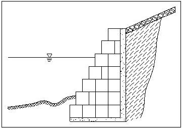
Numerous materials have been used for bank protection, including dumped rock, Portland cement concrete, sacked sand-cement, soil cement, gabions, and precast blocks.
