Section 5: Highways Upstream of Dams
Anchor: #i1000608New Location Highways
Locating a new highway upstream of a dam and within the influence of a reservoir is usually not practicable for the department. However, if a reservoir must be crossed, the highway profile should be set high enough to reduce the risk of overtopping, and the embankment should be stabilized to prevent deterioration from water saturation and wind effects. This section provides specific criteria for setting the elevation and providing for protection of the highway embankment and structures.
Anchor: #i1000618Existing Highways
When a proposed reservoir is expected to impound floodwater on an existing highway location, ust the highway should be adjusted to meet the same conditions of structure size, embankment elevation, and protection that apply to new locations. The roadway should also be upgraded to meet current geometric design standards. All adjustments to the highway are usually the responsibility of the reservoir sponsor, as stated in the Texas Administrative Code 43 TAC 15.54(f). "Department" in this context refers specifically to TxDOT.
"(f) Highway adjustments for reservoir construction.
"(1) Where existing highways and roads provide a satisfactory traffic facility in the opinion of the department and no immediate rehabilitation or reconstruction is contemplated, it shall be the responsibility of the reservoir agency, at its expense, to replace the existing road facility disturbed by reservoir construction in accordance with the design standards of the department, based upon the road classification and traffic needs.
"(2) Where no highway or road facility is in existence but where a route has been designated for construction across a proposed reservoir area, the department will bear the cost of constructing a satisfactory facility across the proposed reservoir, on a line and grade for normal conditions of topography and stream flow, and any additional expense as may be necessary to construct the highway or road facility to line and grade to comply with the requirements of the proposed reservoir shall be borne by the reservoir agency."
Reservoirs that fall into this category are usually major facilities. The reservoir designs are usually well documented and available for the hydraulic designer's use in the analysis.
Anchor: #i1000632Minimum Top Establishment
The roadway embankment elevation should be measured at the point of the low shoulder (crown line), as shown in Figure 12-1.
Figure 12-1. Reservoir Freeboard Requirement
The minimum top of embankment elevation should be set no lower than the elevation created by the higher of the following conditions:
- Anchor: #GIOLILFL
- the 2% AEP reservoir surface elevation for the entire reservoir, plus a minimum freeboard of 3-feet, Anchor: #MKILKEGE
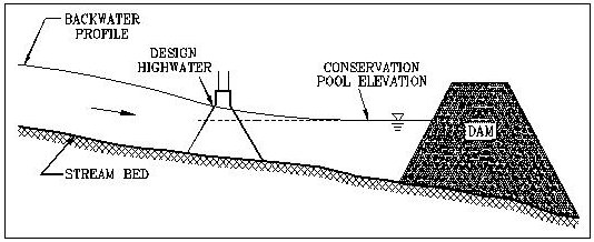
- the elevation of the 2% AEP flood backwater curve as depicted in Figure 12-2, plus a minimum 3-feet freeboard to the low chord elevation of any structure, Anchor: #MNQLGEEM
- the elevation of the 0.2% AEP flood backwater for interstate highways and evacuation routes.
At times the crossing may be located on a tributary to the reservoir. Structures so located may at times operate independently from the reservoir, in which case the water surface elevation should be determined according to Chapter 9, Section 4, Hydraulics of Bridge Openings. In cases where the crossing is located on a tributary, the minimum top of embankment should be set to the higher of the reservoir requirements above and the results of the procedure in Chapter 9.
Figure 12-2.
Anchor: #i1000693Structure Location
Hydraulic structures located within the reservoir generally need not be situated in accordance with the stream crossing design process and guidelines outlined in Chapter 9 because the velocities are usually so low as to be insignificant. However, additional openings in the highway embankment may be needed for flood flow conditions, and near the borders of the reservoir to ensure reservoir normal circulation.
Anchor: #i1000727Scour Considerations
Scour is typically not an issue for a bridge over a reservoir because the velocities are usually so low as to be insignificant. The exception to this is a structure located at the upper end of, or on a tributary of, the reservoir. This structure may at times operate independently from the reservoir, therefore experiencing higher velocities. In this case, scour depths should be calculated as if the bridge were located solely on the tributary.

