Chapter 7: Reference Markers & Coordinates
Anchor: #i1009126Section 1: Reference Markers — Key Points to Know
Anchor: #i1009133Reference Marker Defined
The Reference Marker is the TRM building block, the link between the automated files and what is actually on the ground. Reference markers replace control-section-milepoint, milepost, link-node, and others as the sole source of location identification for highway-related on-system data.
Anchor: #i1009156This Chapter
This chapter describes reference markers and coordinates, the offices of responsibility, input instructions, and includes discussions of the Global Positioning System (GPS) and the Geographic Information System (GIS).
Anchor: #i1009175Offices of Responsibility
The TRM Section of each district office is the Office of Primary Responsibility for reference markers. Responsibilities include:
- Installing
- Maintaining
- Indicating on highway construction plans
- Adding all markers to established routes in TRM.
TPP is the Office of Secondary Responsibility for reference markers. Responsibilities include documenting markers in TRM for new construction. TPP documents the first marker, plus any other markers shown on the construction plans, when first establishing the route in TRM.
Click this link for your district’s TRM analyst.
Anchor: #i1009227Reference Marker Numbering System
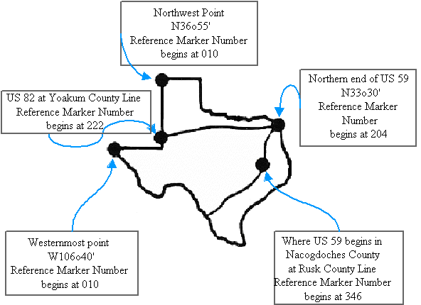
TxDOT derives Reference marker numbers by imposing a grid on a map of Texas. Grid axes are set on extreme western and northern points, where numbering begins with ten. The first reference marker numbers match approximate grid locations. Subsequent marker numbers increase by two. Numbers increase north to south and west to east, depending on the highway's general direction (except north‑south interstates, where numbers increase south to north). The numbers are continuous from beginning to end across the state and do not start over at county lines.
EXAMPLE: US 82 begins at Reference Marker 222 on the western edge of Yoakum County and ends at Reference Marker 798 on the eastern edge of Bowie County:
Figure 7-1. Sample of Reference Marker grid.
Anchor: #i1009252History
The initial installation of reference markers used existing milepost locations and a mile post/reference marker equivalency listing as a control document during the identification and installation process. Reference Marker Coordinators identified locations of the existing mile posts within a 0.01-mile accuracy to its equivalent control-section-milepoint. Then they verified the displacement or notified TPP of the correct displacement, measured up to 3 decimal places. The districts completed this project August 1990.
Anchor: #i1009262Definitions
Reference Marker Group—Consists of the Reference Marker Number + Reference Marker Suffix + Reference Marker Displacement. Process reference markers as point data; add, delete, or update up to eight markers to TRM in one transaction. Do not update the same marker more than once per transaction:
- Number—Official number posted on the signed highway. Used together with the other components of the Reference Marker Group to locate roadway data in TRM. Determine valid values by the function. TRM numbers markers from state line to state line and from westernmost or northernmost point of the Highway origin. (South to north for Interstate Highway post numbering.) Valid values: 0000 to 9999 (for interstate highways); 0010 to 9998 (for non-interstate highways)
- Suffix—Posted suffix character, if any, appended to the Reference Marker Number on the signed highway. Used together with the other components of the Reference Marker Group to locate data on the highway in TRM. Valid values: Blank (no suffix) or A thru Z
- Sign—Symbol indicating the ascending or descending direction to a data attribute or feature from a posted reference marker. Valid values: + (displacement in ascending reference marker direction) or – (displacement in descending reference marker direction).
- Displacement—Distance in miles from a posted reference marker on the signed highway to a data attribute or feature. Used together with the other components of the Reference Marker Group to locate data on the highway in TRM. Valid values: 00.000 to 99.999
-
Figure 7-2. Reference marker example.
- Distance From Previous Marker—System-generated value of distance, in miles, from a reference marker posted on the signed highway to the next sequential marker located on the same signed highway. Valid values: 00.000 to 99.999.

