Section 5: Roadbed-Specific Attributes
Anchor: #i1008931Other Pavement Data
The remaining pavement attributes are roadbed-specific, divided by responsibility of the District Offices or Construction Division:
|
District Input |
District Input |
|---|---|
|
Speed Limit Maximum |
|
|
Speed Limit Minimum |
|
|
Surface Width |
|
|
Number of Thru Lanes |
|
|
Construction Division Input |
|
|
Load Limit Gross |
|
|
Shoulder Width Inside/Outside |
Load Limit Tandem |
IMPORTANT:
- Roadbed-specific attributes cannot cross highway design changes, i.e., changes from a single roadbed to a boulevard then back to a single roadbed
- Due to Roadbed Classification constraints, you cannot input the roadbed-specific pavement attributes at the same time as the centerline or mainlane centerline pavement attributes
- The system compares the value of the roadbed-specific attributes to the values stored in TRM for the centerline and mainlane centerline attributes to ensure that all meet the pavement width requirements.
Definitions
Base Type Values—Material used as the base layer of the pavement structure for a roadbed segment:
|
Value |
Base Type |
|---|---|
|
1 |
Roadbed soil |
|
2 |
Flex Base (Granular) |
|
3 |
Stabilized Earth or Flex (Granular) |
|
8 |
Asphalt Base (Hot mix, asphaltic concrete) |
|
9 |
Concrete |
Curb—A vertical or sloping member along the edge of a pavement or shoulder forming part of a gutter, strengthening or protecting the edge and clearly defining the edge to vehicle drivers.
Curb Type Left/Right Values—A description of the type of curb located on the left or the right of a given roadbed. Left or right is determined by travelling in ascending marker direction:
|
Value |
Curb Types |
|---|---|
|
0 |
None |
|
1 |
Curb (surface drainage only) |
|
2 |
Curb (sub-surface only) |
|
3 |
Overlaid curb (resurfaced so the curb no longer functions as a curb) |
|
4 |
Overlaid curb (resurfaced so the curb no longer functions as a curb with/without opening to the sub-surface drainage) |
Load Limit:
- Load Limit Axle
- Gross—Posted legal maximum load carried by a vehicle on a roadbed segment.
- Tandem—Posted legal maximum load carried by two or more axles in tandem on a roadbed segment.
Number of Thru Lanes—Number of thru driving lanes existing on a roadbed segment, excluding any special lanes such as turn lanes, acceleration/deceleration lanes, or passing/climbing lanes.
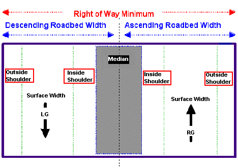
Shoulder—Portion of the roadway adjacent to the traveled way (on either side) for accommodation of stopped vehicles, for emergency use, and for lateral support of base and surface. Illustration:
Figure 10-3. Inside/outside shoulders.
Shoulder Type Inside/Outside Values—Indicates the type of materials that compose the inside or outside shoulder:
|
TRM Values |
Shoulder Type |
HPMS Equivalent Values |
|---|---|---|
|
1 |
None (no shoulders exist) |
1 |
|
2 |
Surfaced with bituminous material |
2 |
|
3 |
Surfaced with concrete (not tied to mainlane pavement) |
2 |
|
4 |
Surfaced with concrete (tied to mainlane pavement) |
2 |
|
5 |
Stabilized-surfaced with flex base, etc. |
3 |
|
6 |
Combination-surface/stabilized or stabilized/earth |
4 |
|
7 |
Earth-natural earth with or without turf |
5 |
Shoulder Use Inside/Outside Values—Indicates shoulder use on the inside or outside of the roadbed segment:
|
Values |
Shoulder Use |
|---|---|
|
00 |
No designated use |
|
01 |
Diagonal parking |
|
02 |
Parallel parking |
|
03 |
Bicycle |
|
04 |
Bus |
|
05 |
No parking (emergency only) |
|
06 |
No parking (peak hours only) |
|
07 |
Other |
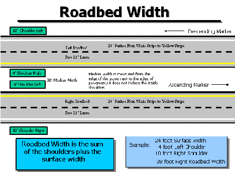
Shoulder Width Inside/Outside—The width, in feet, of the shoulder on the left or right side of a roadbed segment:
Figure 10-4. Green boxes indicate 2-10’ outside shoulders and 2-4’ inside shoulders.
Speed Limit Minimum/Maximum—Posted legal minimum/maximum speed limit for vehicles on a roadbed segment, up to 75 miles per hour (mph).
Surface Type Values—Indicates the material used as the surface layer of the roadbed segment pavement. Surface layer covers the driving lane portion of the roadbed:
|
TRM Values |
Surface Type |
HPMS Equivalent Values |
|---|---|---|
|
20 |
Unimproved Road |
1 |
|
30 |
Graded and Drained |
1 |
|
40 |
Soil, Gravel or Stone |
1 |
|
51 |
Bituminous Surface Treated |
2 |
|
52 |
Mixed Bituminous-Low Type, less than 7" base and surface |
3 |
|
53 |
Bituminous Penetration, less than 7" base and surface |
3 |
|
61 |
High Flexible-mixed, bituminous 7" base and surface |
4 |
|
62 |
Flexible Over Rigid, 7" base and surface |
6 |
|
71 |
High Rigid-plain Jointed Concrete Pavement |
5 |
|
72 |
High Rigid-reinforced Jointed Concrete Pavement |
5 |
|
73 |
High Rigid-continuous Reinforced Concrete Pavement |
5 |
|
74 |
Rigid Over Rigid-bonded Concrete Over Concrete |
5 |
|
75 |
Rigid Over Rigid-unbonded Concrete Over Concrete |
5 |
|
76 |
Rigid Over Flexible-concrete Over Bituminous |
5 |
|
80 |
Other (Brick, Block, etc) |
4 |
Surface Width—Measurement, in feet, of the width of the portion of a physically separate roadbed used as thru driving lanes. Includes any center turn lanes and/or flush paved medians
Anchor: #i1009065Input—Roadbed-Specific Attributes
Districts, follow these input instructions to update roadbed-specific attribute values. Update several Pavement attributes in the same transaction provided that all attributes are continuous within the same From and To Marker limits and are the same Roadbed-Id:
|
Step |
Action |
Input |
|---|---|---|
|
1 |
(For instructions to log onto the system, click this link) From the District Database Maintenance Menu, select Update-Code 13H and press <E>; the District Length Data Update screen appears |
- |
|
2 |
Input Location Key fields |
|
|
3 |
Enter remaining fields with updated information and press <F2>; the system updates the attribute and the verification message “Transaction completed successfully” appears. The original request for the current attributes to update displays for another update transaction |
|
|
4 |
To enter another Update-Code, press <F3> once to exit back to the District Database Maintenance Menu. To exit back to the TRM Main Menu, press <F10> (For instructions to log off the system, click this link) |
- |
Construction Division, follow these input instructions to update load limit values. Update several Pavement attributes in the same transaction provided that all attributes are continuous within the same From and To Marker limits and are the same Roadbed-Id:
|
Step |
Action |
Input |
|---|---|---|
|
1 |
(For instructions to log onto the system, click this link) From the TRM Main Menu, select C, CST Database Maintenance and press <E>; the Load Limit Data Screen appears |
- |
|
2 |
Input Location Key fields |
|
|
3 |
Enter Load Limit fields with updated information and press <F2>; the system updates the record. A verification requests the current location of another attribute to update plus any required fields |
Valid values: 000000 to 999999 |
|
4 |
To exit back to the TRM Main Menu, press <F10> (For instructions to log off the system, click this link) |
- |

