Chapter 11: Features
Anchor: #i1085482Section 1: Key Points to Know
Anchor: #i1085488Feature Data Defined
Feature data consists of roadway features created almost exclusively for display on the Automated Roadway Inventory Diagram (ARI). This chapter describes the features included in TRM and gives detailed instructions for adding, deleting, or updating features and their attributes.
Anchor: #i1085504TRM Features/Responsible Office Table
The TRM Features Table lists each roadway feature; information provided includes:
- Features within each selection
- Valid Roadbed-IDS.
TRM Feature maintenance for which TPP is responsible:
|
Feature Category |
Feature Includes: |
Valid Roadbeds |
|---|---|---|
|
Boundary Data |
C, N, X, Y, A, B |
|
|
Feature Data |
|
K, R, L, M, S, T, P, X, Y, A, B, N |
TRM Feature maintenance for which TPP and the districts are responsible:
|
Feature Category |
Feature Includes: |
Valid Roadbeds |
|---|---|---|
|
Feature Data |
K, R, L, M, S, T, P, X, Y, A, B, N |
TRM Feature maintenance for which districts are responsible:
|
Feature Category |
Feature Includes: |
Valid Roadbeds |
|---|---|---|
|
Feature Data |
|
K, R, L, M, S, T, P, X, Y, A, B, N |
Click this link for your district’s TRM analyst.
Anchor: #i1085546Definitions
Feature Skew—Identifies the Quadrant, Type of intersection, and Angle from perpendicular of an intersecting roadway or feature; format is QIAA:
- Quadrant (Quad)
Anchor: #i1107488Feature Skew Quadrant Value
Quadrant
1
Right Forward
2
Right Back
3
Left Back
4
Left Forward
- Intersection Type
Anchor: #i1052274Feature Skew Intersection Type Value
Type of intersection
0
Stops at roadbed/centerline
1
Continues across roadbed/centerline
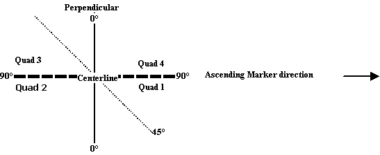
- Angle of intersecting feature (see Figure 11‑1 below)
Anchor: #i1052287Feature Skew Intersecting Feature Angle - Created with imaginary perpendicular line from the intersecting feature.
- Input values are: 00 - 90 (degree increments)
Illustration:
Figure 11-1. Quad-Intersection Type-Skew Angle: 3-1-45
Find the Roadway Feature Skew by placing an imaginary perpendicular line at the centerline point of the intersection and matching the quad with the angle of intersection based on ascending reference marker direction; this creates four imaginary quadrants, or “quads”.
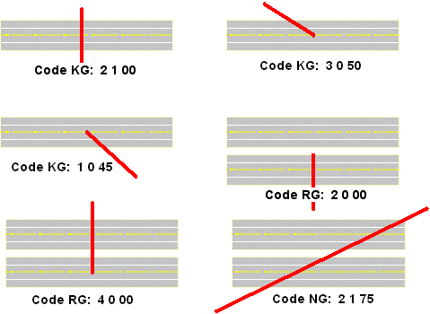
Give the quad in which the intersecting feature is located a value (in Figure 11‑2, the red line represents the intersecting feature at centerline). Perpendicular features that lie between quads are input in either one:
Figure 11-2. Examples of quads-intersection types-skew angles.
Intersecting Feature Type Values—Distinguishes between different intersecting features:
|
Value |
Feature |
Value |
Feature |
|---|---|---|---|
|
11 |
On-System Mainlane |
73 |
Culvert Flowing Left |
|
21 |
Local Road |
74 |
Culvert Flowing Right |
|
31 |
On-System Frontage Road |
75 |
Culvert Flowing Both Directions |
|
41 |
Federal Lands Road |
80 |
|
|
51 |
State Lands Road |
81 |
Transmission Line |
|
61 |
On-System Toll Road Frontage Roads |
82 |
Telephone Line |
|
65 |
83 |
Water Line |
|
|
66 |
Turnaround Backward |
90 |
Pedestrian Passageway |
|
67 |
Turnaround Forward |
91 |
Cattle Guard |
|
70 |
Railroad Crossing |
92 |
|
|
71 |
Stream Flowing Left |
93 |
Overhead Sign |
|
72 |
Stream Flowing Right |
99 |
Other Intersecting Feature |
EXAMPLE: A ramp is a roadway feature with Roadway Feature value 32. A crossover is an intersecting roadway feature with Roadway Feature value 33 and Intersecting Feature Type value 65. The Roadway Feature value for all intersecting roadway features is 33.
Intersection Type Values—Distinguishes the grade of the intersecting feature:
|
Value |
Type |
|---|---|
|
A |
At- grade intersection |
|
B |
Grade separated intersection (no ramps or connectors) |
|
C |
Interchange (at least one ramp and/or connectors) |
|
D |
Channelized intersection |
Roadway Feature Values—Distinguishes between different features:
|
Value |
Feature |
|---|---|
|
24 |
Gap (System Generated) |
|
25 |
|
|
31 |
|
|
32 |
|
|
33 |
|
|
34 |
|
|
35 |
|
|
36 |
|
|
41 |
Roadside feature |
|
99 |
Other feature (not intersecting) |
Roadway Grade Values—Horizontal Level of roadbed:
|
Value |
Feature Grade |
|---|---|
|
U |
Feature is Up above grade |
|
G |
Feature is at-Grade |
|
D |
Feature is Down below grade |
Anchor: #i1085627
General Feature Constraints
Apply these constraints when adding, updating, or deleting roadway features:
|
Action |
Description |
|---|---|
|
Add, update, or delete |
All roadway features as point data |
|
Do not update |
If the Signed Highway is incorrect; delete and re-enter the feature record |
|
Update either |
The feature’s location point OR the feature’s data attributes. If updating both, input two transactions |

