Section 6: Redesignating Routes
Anchor: #i1021074Route Redesignation Defined
Route Redesignation involves changing the Texas Transportation Commission-approved designation of a route or route segment to that of another Texas Transportation Commission-approved designation. The new designation is either new to TRM or increases the mileage of another highway already existing in TRM.
Anchor: #i1021084Important Redesignation Caution
CAUTION: Inputting a route redesignation is one of the more complicated and hazardous functions in TRM. Input this function improperly and lose data or place data incorrectly on the route!
Anchor: #i1021094Definitions
Old Distance From Origin—System-generated value of former Distance From Origin of a given reference marker. Length includes the lengths of all linked route segments with local roads and other signed highways occurring up to that point.
Old Reference Marker:
- Number—System-generated value of number formerly assigned as a reference marker, changed to the current Reference Marker Number. Determine valid values by the function
- Suffix—System generated suffix assigned to the Old Reference Marker Number, changed to the current Reference Marker Number
- Displacement—System-generated value of displacement from a Reference Marker Number to the beginning or ending of a change in signed highway or roadbed-id limits.
Old Roadbed-Id—System-generated identification of a Roadbed-Id formerly associated with a specific roadbed on a highway segment, changed to the current Roadbed-Id.
Old Signed Highway—Consists of the Old Signed Highway System + Old Signed Highway Number + Old Signed Highway Suffix:
- System—System-generated field of highway system associated with the Old Signed Highway, changed to the new Signed Highway System due to route redesignation
- Number—System-generated identification number associated with the Old Signed Highway System. This is part of the Old Signed Highway, changed to the current Signed Highway Number
- Suffix—Character appended to the Old Signed Highway Number that is associated with the Old Signed Highway; field changed to the current Signed Highway Suffix.
Previous Reference Marker Number and Suffix—System-generated Reference Marker Number posted on the signed highway route prior to another reference marker on the same Signed-Highway, with system-generated posted suffix character, if any, for the Previous Reference Marker.
Redesignation Reference Marker Group—Consists of the Redesignation Reference Marker Number + Redesignation Reference Marker Suffix + Redesignation Reference Marker Displacement:
- Number—Marker number closest to either the beginning or ending of a redesignated route segment. Used together with the other components of the Redesignation Reference Marker Group to identify the redesignated route segment
- Suffix—Character, if any, appended to the Redesignation Reference Marker Number. Used together with the other components of the Redesignation Reference Marker Group to identify the redesignated route segment.
- Sign—Symbol indicating the ascending or descending direction to either the beginning or ending of a redesignated route segment. Used together with the other components of the Redesignation Reference Marker Group to identify the redesignated route segment
- Displacement—Distance in miles from a posted reference marker on the Redesignation Signed Highway route to either the beginning or ending of a redesignated segment. Used together with the other components of the Redesignation Reference Marker Group to identify the redesignated route segment
Signed Highway—Consists of the Redesignation Signed Highway System + Redesignation Signed Highway Number + Redesignation Signed Highway Suffix:
- System—Represents the posted designation approved by the Texas Transportation Commission for a segment of highway. Segment is either a new designation to the highway system or a redesignated existing route which will be receiving additional mileage and data from another already existing route or route segment
- Number—Identification number associated with the Redesignation Signed Highway System serving as the receiving route. Valid values: 0001 – 9999, NASA, or OSR
- Suffix—Character appended to the Redesignation Signed Highway Number to further partition the number or, in the case of business routes, to indicate geographical routing. Determine valid values by the Redesignation Signed Highway System.
For each situation of redesignation, two routes are involved: the sending route and the receiving route:
Sending Route—Identifies the redesignated route or route segment
Receiving Route—Identifies the route or route segment becoming a new route in TRM, or additional mileage to a route already existing on the file.
Anchor: #i1021222Determining the Redesignation Situation
To determine the appropriate redesignation situation, identify the relationship between the sending route and receiving route. For example, if the newly redesignated segment (sending route) is contiguous to the beginning of a route already existing in TRM (receiving route), select Situation C and proceed to the appropriate section:
The five general redesignation situations are divided into two categories:
|
The redesignation creates a brand new route not in TRM: |
|
|---|---|
|
Redesignate Entire Route |
|
|
Redesignate Partial Route Section |
|
|
The redesignation increases the mileage of a route in TRM: |
|
|
Redesignate Contiguous to Begin of Route |
|
|
Redesignate Contiguous to End of Route |
|
|
Redesignate Contiguous to Fill a Gap |
|
Anchor: #i1021236
Caveats to All Redesignations
Always keep these warning in mind when redesignating highways in TRM:
- Do not redesignate Interstate Highways to non-interstate highways
- Do not redesignate non-interstate highways to Interstate Highways if the sending route’s Roadbed-Id = K
- Do not redesignate segments containing more than 50 markers.
Input—Situation A: Entire Route to New Designation
Redesignate an entire route to a designation that is new to TRM. In Figure 5‑10, all records and reference markers from the old designation (sending route) transfer to the new designation (receiving route).
Figure 5-10. Redesignate entire Highway A as Highway B.
Follow these input instructions for Redesignation Situation A:
|
Step |
Action |
Input |
|---|---|---|
|
1 |
(For instructions to log onto the system, click this link) From the TPP Database Maintenance Menu, select Update-Code 33A and press <E>; the TPP Redesignation Submenu appears |
- |
|
2 |
Input A and press <E>; the Network Change Data screen appears |
- |
|
2 |
Input redesignation fields and press <F2>; a prompting message “Press PF2 to confirm or PF 11 to cancel” appears |
|
|
4 |
Repress <F2> to confirm the route or route segment redesignation; the system updates the route and the verification message “Transaction completed successfully” appears. The original request for redesignation displays for another update transaction |
OR Press <F11> to cancel redesignation; the system takes no action |
|
4 |
To select another redesignation type, press <F3> to exit back to the TPP Redesignation Submenu To input another Update-Code, press <F3> twice to exit back to the TPP Database Maintenance Menu To exit back to the TRM Main Menu, press <F10> (For instructions to log off the system, click this link) |
- |
System Response. While making this new designation, the TRM system automatically:
- Transfers reference markers and all data values which once resided on the original designation to the new designation
- Disposes of the data records stored with the sending route.
Input—Situation B: Partial Route Section to New Designation
Redesignate a segment of an existing route to a new designation. All records from the old designation (sending route) transfer to the new designation (receiving route) and create a gap situation within the sending route:
- The sending route segment cannot contain a link or gap
- The ‘From’ and ‘To’ Reference Marker fields input for the sending route define the limits of the segment being redesignated
- The marker location input as the ‘From’ Reference Marker must be physically closest to the beginning of the new designation
- Reference marker transfer to the new designation depends upon the overall direction of the new route after redesignation.
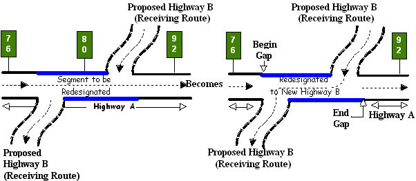
Example 1: In Figure 4‑11, the route segment being redesignated travels west to east. The overall direction of the new designation is west to east. Marker 76 is closest to the beginning of the newly-designated route. Therefore, input ‘From’ = 76 and ‘To’ = 92 markers in ascending marker direction:
Figure 5-11. Redesignating a segment of Highway A to Highway B, ascending marker direction.
Example 2: In Figure 4‑12, the route segment being redesignated travels west to east. The overall direction of the new designation is north to south. Marker 92 is closest to the beginning of the newly designated route. Therefore, input ‘From’ = 92 and ‘To’ = 76 markers in descending marker direction.
Figure 5-12. Redesignating a segment of Highway A to Highway B, descending marker direction.
This creates a gap in the sending route where the redesignated segment was. Because the route direction changed, no markers are transferred to the new designation.
Follow these input instructions for Redesignation Situation B:
|
Step |
Action |
Input |
|---|---|---|
|
1 |
(For instructions to log onto the system, click this link) From the TPP Database Maintenance Menu, select Update-Code 33A and press <E>; the TPP Redesignation Submenu appears |
- |
|
2 |
Input B and press <E>; the Network Change Data screen appears |
- |
|
3 |
Input Location Key fields and press <E>; the system retrieves record data from TRM. A prompting message “Enter Redesignation Data” appears |
|
|
4 |
Input redesignation fields and press <F2>; a prompting message “Press PF2 to confirm or PF 11 to cancel” appears |
|
|
5 |
Repress <F2> to confirm the route or route segment redesignation; the system updates the route and the verification message “Transaction completed successfully” appears. The original request for redesignation displays for another update transaction |
OR Press <F11> to cancel redesignation; the system takes no action |
|
6 |
To select another redesignation type, press <F3> to exit back to the TPP Redesignation Submenu To input another Update-Code, press <F3> twice to exit back to the TPP Database Maintenance Menu To exit back to the TRM Main Menu, press <F10> (For instructions to log off the system, click this link) |
- |
System Response. While completing this redesignation, the system automatically:
- Creates:
-
- the new route with the new designation
- a gap record within the sending route where the redesignated segment use to be, when applicable
- a record with placeholder marker 0000 if a marker is not located at the exact beginning of the new designation
- a record with placeholder marker 9999 if a marker is not located at the exact ending of the new designation
- Deletes:
-
- curve and station data if the overall direction changed. Find this data in the Transaction file
- the reference markers if the overall direction changed, or transfers the markers to the new route
- Transfers all data values with the new designation if the overall route direction of the new segment is the same. Either references data from transferred markers, or from marker 0000 if no markers transferred
- Calculates:
- Treats the data records stored with the sending route as deleted route segment data
- Adds new markers which conform to the overall route direction and grid map location
- If the redesignation segment begins and/or ends at whole markers, the whole reference markers remain on the old route and transfers to the new route.
Input—Situation C: Contiguous Segment to Beginning of Existing Route
After redesignation, the newly redesignated segment is contiguous with the receiving route at the beginning of the receiving route, adds additional mileage to the receiving route, and creates a new beginning of the receiving route:
- The sending route segment cannot contain a link or gap
- The ‘From’ and ‘To’ Reference Marker fields input for the sending route define the limits of the redesignated segment. Input only the ‘To’ Marker fields for the receiving route
- The marker location input with the ‘To’ Marker fields for both the sending and receiving routes must be physically closest to the beginning of the receiving route.
Example 1: In Figure 4‑13, the receiving route, Highway B, travels west to east as does the sending route, Highway A. Marker 40 on the redesignated segment is closest to the beginning of the receiving route. Therefore, ‘From’ = 36and ‘To’ = 40 are the marker locations for the redesignated segment. Input Marker 92 with the ‘To’ Marker location fields of the receiving route.
Figure 5-13. Redesignating a contiguous segment of Highway A as Highway B at the beginning of Highway B, ascending marker direction.
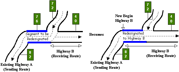
Example 2: In Figure 4‑14, the receiving route travels west to east and the sending route travels north to south. In this case, Marker 76 on the redesignated segment is closest to the beginning of the receiving route. Therefore, ‘From’ = 82 and ‘To’ = 76 are the marker locations for the redesignated segment. Input Marker 40 with the ‘To’ Marker location fields of the receiving route.
Figure 5-14. Redesignating a contiguous segment of Highway A as Highway B at the beginning of Highway B, descending marker direction.
Follow these input instructions for Redesignation Situation C:
|
Step |
Action |
Input |
|---|---|---|
|
1 |
(For instructions to log onto the system, click this link) From the TPP Database Maintenance Menu, select Update-Code 33A and press <E>; the TPP Redesignation Submenu appears |
- |
|
2 |
Input C and press <E>; the Network Change Data screen appears |
- |
|
3 |
Input Location Key fields and press <E>; the system retrieves record data from TRM. A prompting message “Enter Redesignation Data” appears |
|
|
4 |
Input redesignation fields and press <F2>; a prompting message “Press PF2 to confirm or PF 11 to cancel” appears |
NOTE: Do not input the Redesignation ‘From’ Reference Marker fields
|
|
5 |
Repress <F2> to confirm the route or route segment redesignation; the system updates the route and the verification message “Transaction completed successfully” appears. The original request for redesignation displays for another update transaction. |
OR Press <F11> to cancel redesignation; the system takes no action |
|
6 |
To select another redesignation type, press <F3> to exit back to the TPP Redesignation Submenu To input another Update-Code, press <F3> twice to exit back to the TPP Database Maintenance Menu To exit back to the TRM Main Menu, press <F10> (For instructions to log off the system, click this link) |
- |
System Response. While making this new designation, the system automatically:
- Deletes all reference markers from the newly redesignated segment, but transfers all data values with the new designation
- Creates a new record with placeholder marker 0000 to mark the exact beginning of the route
- Stores all data values transferred to the new route based off of marker 0000
- Recalculates
-
- DFO for all markers residing on the receiving route to account for the additional mileage
- Distance between markers for the displacement between the first marker on the receiving route and marker 0000 to account for the additional mileage
- Disposes of the data records stored with the sending route as deleted route or route segment data. If applicable, creates a gap in the sending route for the redesignated section.
- If the direction of travel of the newly redesignated route is reversed, the system removes curve and station data. Find this information in the Transaction file.
Input—Situation D: Contiguous Segment to End of Existing Route
After redesignation, the newly redesignated segment is contiguous with the receiving route at the ending of the receiving route, adds additional mileage to the receiving route, and creates a new ending of route:
- The sending route segment cannot contain a link or gap
- Define the limits of the redesignated segment with the ‘From’ and ‘To’ Reference Marker fields input for the sending route. Input only the ‘From’ Marker fields for the receiving route
- The marker location input with the ‘From’ Marker fields for both the sending and receiving routes must be physically closest to the ending of the receiving route.
Example 1: In Figure 5‑15, the receiving route travels west to east and the sending route also travels west to east. Marker 88 on the redesignated segment is closest to the ending of the receiving route. Therefore, ‘From’ = 88 and ‘To’ = 92 are the marker locations for the redesignated segment. Input Marker 36 with the ‘From’ Marker location fields of the receiving route.
Figure 5-15. Redesignating a contiguous segment of Highway A as Highway B at the end of Highway B, ascending marker direction.
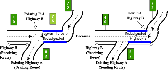
Example 2: In Figure 5‑16, the receiving route travels west to east and the sending route travels north to south. In this case, Marker 82 on the redesignated segment is closest to the ending of the receiving route. Therefore, ‘From’ = 82 and ‘To’ = 72 are the marker locations for the redesignated segment. Input Marker 40 with the ‘From’ Marker location fields of the receiving route.
Figure 5-16. Redesignating a contiguous segment of Highway A as Highway B at the end of Highway B, descending marker direction.
Follow these input instructions for Redesignation Situation D:
|
Step |
Action |
Input |
|---|---|---|
|
1 |
(For instructions to log onto the system, click this link) From the TPP Database Maintenance Menu, select Update-Code 33A and press <E>; the TPP Redesignation Submenu appears |
- |
|
2 |
Input D and press <E>; the Network Change Data screen appears |
- |
|
3 |
Input Location Key fields and press <E>; the system retrieves record data from TRM. A prompting message “Enter Redesignation Data” appears |
|
|
4 |
Input redesignation fields and press <F2>; a prompting message “Press PF2 to confirm or PF 11 to cancel” appears |
Do Not input the Redesignation ‘To’ Reference Marker fields
|
|
5 |
Repress <F2> to confirm the route or route segment redesignation; the system updates the route and the verification message “Transaction completed successfully” appears. The original request for redesignation displays for another update transaction |
OR Press <F11> to cancel redesignation; the system takes no action |
|
6 |
To select another redesignation type, press <F3> to exit back to the TPP Redesignation Submenu To input another Update-Code, press <F3> twice to exit back to the TPP Database Maintenance Menu To exit back to the TRM Main Menu, press <F10> (For instructions to log off the system, click this link) |
- |
System Response. While making this new designation, the TRM system automatically:
- Deletes all reference markers from the newly redesignated segment, but transfers all data values with the new designation
- Creates a new record with placeholder marker 9999 to mark the exact ending of the route
- Stores all data values transferred to the new route based off the last marker located on the receiving route
- Recalculates:
-
- DFO for marker 9999 to account for the additional mileage
- Distance between markers for the displacement between the last marker on the receiving route and marker 9999 to account for the additional mileage
- Disposes of the data records stored with the sending route as deleted route or route segment data
- The system removes curve and station data, if the direction of travel of the newly redesignated route is reversed. Find this information in the Transaction file.
Input—Situation E: Contiguous Route Segment to Fill Gap
After redesignation, the newly redesignated segment fills the gap between two segments of the receiving route. Add additional mileage to the receiving route. Fill the location of the roadway gap already residing in the receiving route by the mileage of the new segment:
- The sending route segment cannot contain a link or gap
- The ‘From’ and ‘To’ Reference Marker fields input for the sending route define the limits of the redesignated segment. Only input the ‘From’ Marker fields for the receiving route
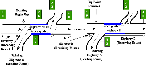
- The marker location input with the ‘From’ Marker fields for both the sending and receiving routes must be physically closest to the existing begin gap point on the receiving route.
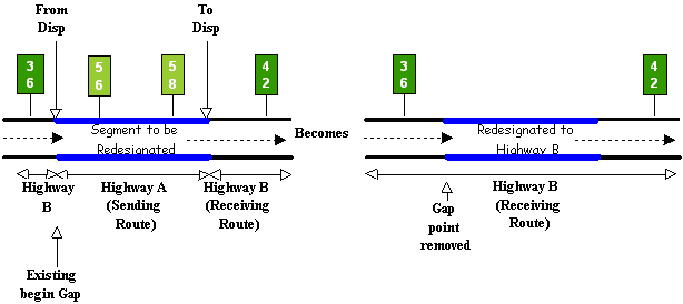
Example 1: In Figure 4‑17, the receiving route travels west to east and the sending route also travels west to east. Marker 56 on the redesignated segment is closest to the existing begin gap point on the receiving route. Therefore, ‘From’ = 56 and ‘To’ = 58 are the marker locations for the redesignated segment. Input Marker 36 with the ‘From’ Marker location fields of the receiving route.
Figure 5-17. Redesignating Highway A to Highway B to fill a gap in Highway B, ascending marker direction.
Example 2: In Figure 4‑18, the receiving route travels west to east; the sending route travels north to south. In this case, Marker 82 on the redesignated segment is closest to the existing begin gap point on the receiving route. Therefore, ‘From’ = 82 and ‘To’ = 76 are the marker locations for the redesignated segment. Input Marker 40 with the ‘From’ Marker location fields of the receiving route.
Figure 5-18. Redesignating Highway A to Highway B to fill a gap in Highway B, descending marker direction.
Follow these input instructions for Redesignation Situation E
|
Step |
Action |
Input |
|---|---|---|
|
1 |
(For instructions to log onto the system, click this link) From the TPP Database Maintenance Menu, select Update-Code 33A and press <E>; the TPP Redesignation Submenu appears |
- |
|
2 |
Input E and press <E>; the Network Change Data screen appears |
- |
|
3 |
Input Location Key fields and press <E>; the system retrieves record data from TRM. A prompting message “Enter Redesignation Data” appears |
|
|
4 |
Input redesignation fields and press <F2>; a prompting message “Press PF2 to confirm or PF 11 to cancel” appears |
Do Not input the Redesignation ‘To’ Reference Marker fields
|
|
5 |
Repress <F2> to confirm the route or route segment redesignation; the system updates the route and the verification message “Transaction completed successfully” appears. The original request for redesignation displays for another update transaction |
OR Press <F11> to cancel redesignation; the system takes no action |
|
6 |
To select another redesignation type, press <F3> to exit back to the TPP Redesignation Submenu To input another Update-Code, press <F3> twice to exit back to the TPP Database Maintenance Menu To exit back to the TRM Main Menu, press <F10> (For instructions to log off the system, click this link) |
- |
System Response. While making this new designation, the TRM system automatically:
- Deletes all reference markers from the newly redesignated segment, but all data values transfer with the new designation
- Recalculates:
-
- DFO for markers past the newly redesignated segment on the receiving route for the additional mileage
- Distance between markers for markers past the newly redesignated segment on the receiving route to account for the additional mileage
- Removes:
-
- the gap point record from the TRM-FEATURE file creating a continuous route flow
- curve and station data if the direction of travel of the newly redesignated route is reversed. Find this information in the Transaction file
- Treats the data records stored with the sending route as deletion route or route segment data.


